Getting to the Summit of Mount Everest. Part 1 - Getting to know the Sagarmatha
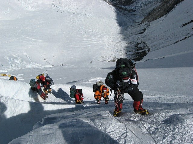.jpg) Going somewhere close to the top of the world
(License: Public Domain]: Pixabay
Going somewhere close to the top of the world
(License: Public Domain]: Pixabay INTRODUCTION
Mount Everest is the highest point on earth above sea level. This is a generally accepted fact. Climbing to the top of Mount Everest as at one point in time been on your bucket list. We are not even going to argue that. Well, maybe we should. But that would be deviating from the actual discussion for today. So let's leave that for another day.
The poor truth is, not everyone will ever be able to tick that line off their bucket list. But if you have been able to read up to this point, it simply means you should be able to read your way through to the top of mount Everest – which is exactly what we are going to do with my first series on steemit - Getting to the Summit of Mount Everest.
We are starting with all we need to know about this tall guy. In the next part of the series, we will try to understand the science of mountaineering and ice climbing – cos trust me, you would be needing those skills. While in the third and final part of the series, we shall begin climbing and I hope we can read our way through to the summit of the Sagarmatha together.
Whether you decide to tick it off your bucket list after this series or not is entirely up to you :p.
If you are reading this and it just happens that you have already been there – done that, please do well to follow the series because your contributions will be highly appreciated.
So today, let’s say Hi to the Chomolungma.
GETTING TO KNOW THE SAGARMATHA
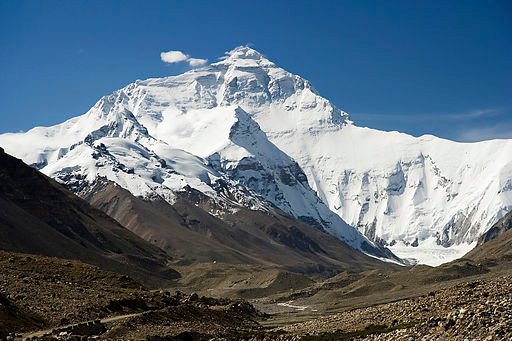 Mount Everest view from the North
(License: CC-BY-SA 3.0, Author: Luca Galuzzi]: Wikicommons
 The highest peak on earth is located between Tibet in China and Nepal, at exactly 27°59′ N 86°56′ E for those of us who still remember our coordinates from elementary geography. It is part of the range of high-peak snow-capped mountains that forms the Himalayas in Asia.
You must have been wondering where the names “Sagarmatha” and “Chomolungma” came from. I did not make those up :D. Mount Everest is known by the natives of Tibet (located north of the mountain) as “Sagarmatha”, translated as “forehead of the sky” or “goddess of the sky”. In Nepal (located south of the mountain), the mountain is known as “Chomolungma”, which translates as “mother goddess of the world”.
These names have been attributed to what was then known as Peak XV even before it was determined by Indian mathematician/surveyor Radnath Sikhdar to have the highest peak on earth, with an elevation of 8,840 m. A conclusion he came to after compiling data from 6 different observations while he was part of the Great trigonometric Survey of India led by Sir George Everest. The survey was a British mission in Asia to fix the attributes of the world’s highest mountains at the time. The latter (Sir Everest) whose name the mountain was named after by the Royal Geographical Society.
The height was eventually determined to be 8,848 m (29,029 ft) by a 1955 Indian survey and confirmed twenty years later from a measurement by the Chinese. This elevation however included the snow cap of about 3.5 m as was later determined by a 2005 findings which measured the actual rock height of the mountain to be 8,844.43 m. Though the snow cap height has been officially adopted as the height of Mount Everest.
Geology of Mount Everest?
If you are wondering why there is a question mark in the above subheading, it is because I may not have done enough justice to this section because of the abstract geologic terms that would come across as strange to the non-geologic inclined readers.
Nonetheless, I start by defining some of the probably unfamiliar terms you will still encounter and I have dropped a link for you further reading on the geology of Mount Everest under the reference list.
Tectonics, as defined by Wikipedia, is the process that controls the structure and properties of the Earth's crust and its evolution through time. Plate tectonics is based on the concept that earth’s continent are slowly but constantly moving relative to each other as they appear to drift across the ocean bed. This concept is known as the Continental drift. I think I would have to write about these things soon. They are some really interesting knowledge to have.
Wikipedia also defines Subduction as a geological process that takes place at convergent boundaries of tectonic plates where one plate moves under another and is forced or sinks due to gravity into the mantle.
Pleistocene Epoch is what is commonly known as the Great Ice Age. It was a period, some 2,600,000 to 11,700 years ago, when extensive ice sheets and glaciers formed repeatedly on earth landmasses.
Britnaccia defines a geologic fault as a planar or gently curved fracture in the rocks of the Earth’s crust, where compressional or tensional forces cause relative displacement of the rocks on the opposite sides of the fracture.
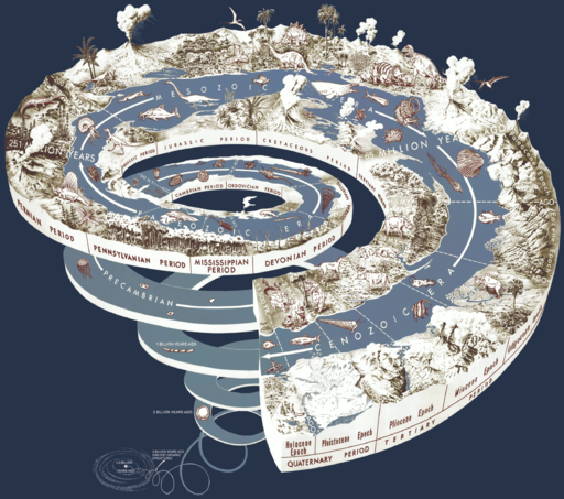 Geological Time Spiral
(License: Public Domain]: Wikicommons
 Ordovician, Cambrian, Paleoproterozoic periods are all part of the geologic time scale. The Cambrian and Ordovician periods are the first and second of the Paleozoic era respectively. The Cambrian period lasted from 542 to 488 million years ago while the succeeding Ordovician period lasted from488 to 443 million years ago. The Paleoproterozoic period is more of the Precambrian era, lasting between 2,500 to 1,600 million years ago. It is the longest era of Earth’s geologic time scale and it is known as the era during which the earth’s continent were first stabilized.
Having defined the above terms, let's get down to business. As earlier mentioned, Mount Everest is part of the Himalayan mountains range in Asia. The Himalayans were thrust upwards to the earth’s surface by tectonic action as the Indian-Australian tectonic plate collided with the Eurasian plate about 40 to 50 million years ago. The collision resulted in the subduction of the former plate under the latter plate. About 20 to 30 million years ago, the Himalayas began to rise and assumed their current form during the Pleistocene Epoch. It has been observed since the1990s that, due to plate tectonics, Mount Everest itself continues to move northeastward by a few inches (about 0.12 to 1.1 inch) each year, and its height increasing at 4 mm (0.16 in) yearly.
The sagarmatha is made up of multiple rock layers that consists of metamorphic materials at lower elevations, followed by igneous granites and then sedimentary rock materials of marine origin at higher elevations.
The rocks that make up Mount Everest have been subdivided into three (3) formations. Starting from the summit of the mountain to its base, the formations (or units) are as follows; The Qomolangma Formation (do not bite your tongue like I did :p), the North Col Formation, and the Rongbuk Formation. These formations are separated by low-angle faults referred to as detachments.
The Qomolangma Formation is also known as the Jolmo Lungama Formation. It begins at the summit and terminates at about 8,600 m above sea level ( or about 250 m from the summit). The Formation comprises of Ordovician limestone, recrystallized dolomite, laminae and siltstone that exist in layers of dark grey to white colour beds. The detachment of this formation is a badly-deformed low-angle fault that lies just above the yellow band. The Yellow band (a sedimentary sandstone rock) is the first rock you get to touch en route the summit of Mount Everest.
The North Col formation begins from the Yellow band (at 8,600 m above sea level) to its detachment at 7,000 m above sea level. The yellow band, which spans about 400 m in depth, consists of linked beds of yellowish-brown Middle Cambrian marble, silicate minerals and metasedimentary rocks known as semischist. The rest of the formation consists of interlayered and deformed schist, minor marble and silicate minerals known as phylite. The formation terminates at a low-angle normal fault known as the Lhotse detachment.
The third and final formation is the Rongbuk formation. (I really need someone to tell me how they come about these names). This is everything from the base to an elevation of 7,000 m. The rocks and minerals that make up this region are formed from the partial melting of metasedimentary tocks during the subduction of the Indian tectonic plate in the Paleoproterozoic to Ordovician era.
Mount Everest has the shape of a three-sided pyramid. These sides – flat planes known as the Sides – are the North Face, Southwest Face and the East face.
The North face can be seen from Tibet and it features two notable narrow and steep gully passages called the Norton and Hornbein Couloirs located at 150 m and 350 m away from the summit respectively. The Norton Couloir is also known as the Great Couloir - for whatever reason, I don’t know.
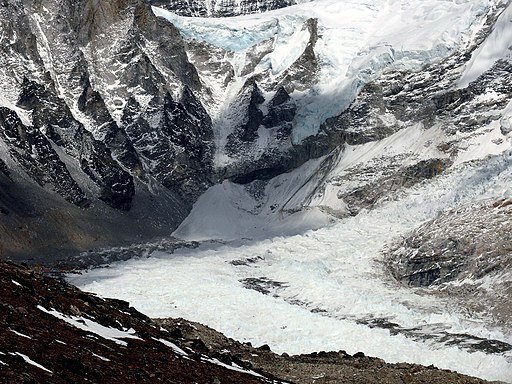 Khumbu Icefall from Kala Patther
(License: CC-BY-SA 4.0]: Wikicommons
Khumbu Icefall from Kala Patther
(License: CC-BY-SA 4.0]: WikicommonsThe Southwest side faces the Nepal region and it features the Khumbu icefall which lies at 5,486 m above sea level. The south route is the most commonly taken to get to the summit of Mount Everest. However, the Khumbu Icefall, located just above the base camp at an elevation of 5,486 m, is one of the most dangerous stages encountered when taking this route. This is because it involves the tumbling of huge blocks of Ice that have sizes ranging from motor vehicles to residential houses. The early hours of the day before sunrise is often the best times to cross this icefall because;
It has partially frozen during the night and is less able to move. As the intense sunlight warms the area, the friction between the ice structure lessens and increases the chances of crevasses opening or blocks of snow and ice falling. Source
The third face – the East (or Kangshung) face – like its Northern Counterpart, can also be seen from Tibet. It is bounded by the Southeast and Northeast Ridges (A ridge is a line that separates two different faces of the mountain).
Climate and Environment
 Mountain top
(License: Public Domain]: Pixabay
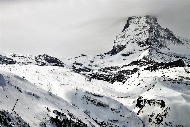
 Mount Everest has extremely cold climatic conditions. You can understand how cold extremely cold here is by relating it to the troposphere-elevation and lapse time (change in temperature with elevation). I discussed the troposphere in one of my posts.
The elevation of the troposphere varies with latitude over the earth’s surface. It is highest at the equator, at about 20, 000 m (65, 000 ft). In the troposphere, temperature and pressure decreases with increasing height, with the topmost part of the troposphere (over the equator) reaching temperatures as low as -57° C (-70° F). Mount Everest is located at 27° 59’ north of the equator. Well, thank goodness this tall boy, though standing at an elevation of 8,848 m above sea level, is not that high, and hence not that cold. However, it is still high enough to be really really cold. Temperatures at the summit of the sagarmatha (I really like this name) averages temperatures of −19 °C (−2 °F) in its warmest months and an average of -36°C (−33 °F) during its coldest periods, sometimes dropping as low as -60 °C (−76 °F). In fact, Mount Everest climbers can be highly exposed to Frost bite (the freezing of one’s skin and underlying tissues when exposed to temperatures below freezing temperature). From the top of the mountain to the base is covered by glaciers and Ice sheets, the most prominent being the Khumbu falls of the South Col.
High-speed winds is another dominating phenomenon on Mount Everest, an issue climbers are often faced with. The wind speeds described below are high enough to blow climbers off the mountain. I think that’s number 974 on 1000 ways to die!
In February 2004 a wind speed of 280 km/h (175 mph) was recorded at the summit and winds over 160 km/h (100 mph) are common. Source
The decreasing pressure with increasing height also has a direct impact on oxygen levels as it reduces the availability of oxygen as one climbs higher the mountain.
As funny and contrasting as it may, one of the most difficult stages of climbing Mount Everest is getting past the Western Cwm because of its extremely hot conditions. Despite its high elevation of about 6,000 m to about 6,800 m, the broad, flat, gently undulating valley reflects solar radiation due to its bowl-shaped slopes, thereby making it constantly warm, especially on windless days.
Life on the Mountain
 Edmund Hillary (left) and Tenzing Norgay (right)
(License: CC-BY-SA 3.0]: Wikicommons
 The climatic conditions described above highly suggests that the mountain is inhabitable by not just humans but most living organisms.
Though plant species like the moss and Arenaria have been found to grow at 6,480 m (21,260 ft) and 5,500 m respectively. A tiny black jumping spider, the Euophrys omnisuperstes, is an insect that can be found at elevations of 6,700 m (22,000 ft).
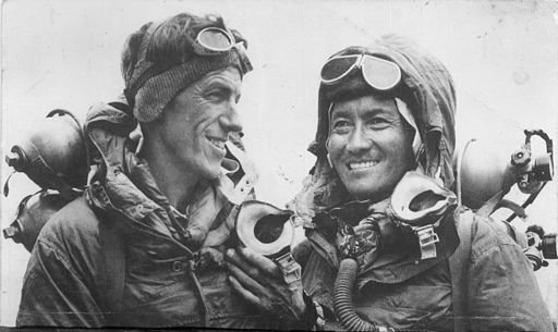
The closest you may get to finding human habitation is in the valleys below the mountain. These valleys are inhabited by the people of Tibet, just north of the mountain. Though at elevations of about 4,270 m (14, 000 ft), you would find the Sherpas, also a Tibet-speaking populace. These Sherpas will be helping us to navigate our way through to the summit of the mountain due to their experience with the mountain’s experience over the years. One of the most notable Sherpas in history is Tenzing Norgay, who accompanied Sir Edmund Hilary to make history as the first persons recorded to get to the summit of the mountain in 1953. What record should we looking to set here? Hmmm…
Take Away Facts about Mount Everest
Now that we have learnt one or two about the Great Sagarmatha (You must be getting tired of me and this name :p), we shall be consider the science of mountaineering and Ice climbing in the next part of this series. But for now, let’s have play around with some interesting facts about Mount Everest that some of us may not have been aware of. You can add yours in the comment section :)
- Neither the Nepalese nor Tibetan governments allowed foreigners into their countries due to political reasons. This would keep prospective climbers from exploring the mountain until 1921 when the Tibet government finally opened their borders. This was followed a few decades later by the Nepalese government opening their own borders too after much negotiations.
Tenzing Norgay and New Zealander, Edmund Hillary were the firsts to make an first official ascent of Everest in 1953, taking the southeast ridge route following the opening of Nepal’s borders.
The first ascent through the North-route was in 1960 by a 3-man Chinese mountaineering team.
Edmund and Tenzing were probably not the firsts to get to the summit of Everest. Brits, George Mallory and Andrew Irvine made an attempt through the North-ridge and were last seen at climing high up the mountain but never returned. Mallory’s corpse was eventually found in 1999 at about 8,220m (27,000 ft) but there was little evidence to tell if they eventually got to the summit.
Climb it or die trying! Though over 2,200 people have succeded in thir attempt to get to the summit of the mountain, well over 200 people have also lost their lives. And since helicopters cannot get to the top of the mountain for obvious reasons, dead bodies are often left behind. So brace yourself when you start climbing cos you are surely gonna meet one or two once-breathing folks, sadly.
Only a few are aware that Mount Everest is literally not the tallest mountain on earth. It only holds this title because it rises to a height of 8,848 m above sea level. Mauna Kea, a volcano on Hawaii’s Big Island, is actually the tallest mountain on earth rising to a height of around 10,000 m (33, 000 ft). But since it rises from the ocean floor, it only attains a height of 4,200 m (13, 796 ft) above sea level.
Now that we know all these and probably more, let’s start getting prepared to do some mountain climbing exercises. :D
Do you write STEM (Science, Technology, Engineering, and Mathematics) related posts? Then you should consider joining the #steemSTEM community on discord here. If you are from Nigeria, you should also consider including the #stemng tag in your post. You can visit @stemng for more information.
REFERENCES
7 Things You Should Know About Mount Everest
How Climbing Mount Everest Works
Temperature in the Troposphere
Indian mathematician Radhanath Sikdar first to identify Everest as highest mountain peak
Great post @writeit! I remembered sometime in early this year, I spend an hour or two before sleeping watching the documentaries about Mt Everest, though it's a great achievement to some that would successfully made it, it's so risky and just one small mistake it would cost someone's life. I did watched documentary specific to the K2, the killer mountain which is amongst the 8k group of mountains XD
You're right man. When I began writing this series I started doubting whether its really worth the risk. A lot of people have been lost to silly causes in attempting to climb the Himalayas.
Well, let's stick to articles and documentaries is what I would say. Thanks for stopping by.
A very beautiful and well-research write-up. I've really learnt more about Mt. Everest than I've ever done before.
Thanks @writeit.
U're really writing it. Such a good writer.
Thanks a lot bro!
I'm giving you an instant follow in fact. :)
I'm glad you found the post interesting.
Things I do not want to do:
No 1: Climb the Mount Everest :)
The Nepalese government has a major tourist attraction because of this mountain.
Things you really really want to do:
1: Climb the Mount Everest :D
Yes o... it has really boosted the economy of that small nation. At a point in time it was regarded as a 4th world nation but now... small nation, big mountain ;)
Thanks for stopping by.
I actively avoided Everest not for its difficulty or whatever, but it is becoming an ecological disaster zone, with a lot of biological waste and trash going up and never coming down again. There are far more beautiful mountain ranges to trek where trash can bee taken away again...
You're right... it was once described as the highest junkyard in the world.
Though the Nepalese government is now taking stringent measures to curb the pollution there. I read somewhere that climbers are required tp make a deposit of i think $4,000 which is only refundable if they return with the same quantity of gears they went up with.
There's still more to be done.
You should add Mt McKinley in Alaska as the most topographically prominent mountain to your list (or so it is claimed). I have to say it is still impressive how that much rock can be thrust up above sea level without self weight pushing it back down - I assume this happens but the uplift keeps driving it upwards.
Anyway @writeit, I really enjoyed the article 👍
Hmmm i should read about it.
Thanks for your contribution man.
sagarmatha ,is the nepali name of mt.everest. it is the highest peak of the world of 8848 meter. thanks to described everyting in detail.
That's correct. Thanks for stopping by man.
thanks you too..
nice post bro i am informed right now
I'm glad you learnt a thing or two. Thanks for coming around bro
ehhehehehhhe for your mind lols
This post has been voted on by the steemstem curation team and voting trail.
There is more to SteemSTEM than just writing posts, check here for some more tips on being a community member. You can also join our discord here to get to know the rest of the community!
It sounds like a very scary place. I have always wondered why people risk their lives to go there. Does it make them feel more worthy? Probably :)
I would never go there but would enjoy a safe and easy read-tour :D
I guess it makes them feel so... I mean, who wouldn't want to feel on top of the world, literally?
Anyway, I guess there's a couple of us who don't have this on our bucket list, so we are in this together. Thank goodness we can at least read :D
I appreciate your comimg by!
Lol
I know i have phobia of heights but stil i'd loved to climb this some day!
Hehe... that makes two of us!
Anything higher than 3 m is too high for me... and here we are talking almost 9000 m. Ahh, i think I'll rather pass.
I think you should pass😉😉
Have fun toooo