How does the Coriolis force determine the spin of a cyclone?
What force determines the spin of a cyclone? This question cannot be answered correctly, without referring to the "Coriolis force", mentioned by and named after Gaspard-Gustave de Coriolis (1792-1843). It was already derived correctly from Pierre-Simon Laplace in 1775 from the Newton's laws of motion, but Coriolis published it and focused on it in a publication in 1835. Because of the highlighting of the force, it was named after Coriolis.
The Coriolis force
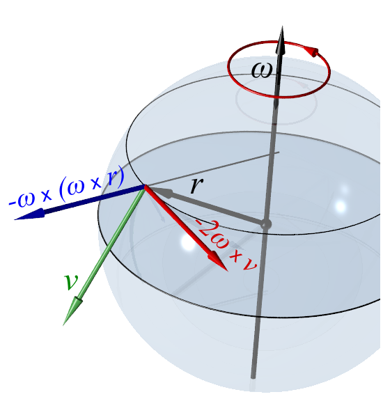
It has an impact on bodies in motion in a a rotating frame of reference and it is a fictious force. It is always perpendicular to the velocity and the axis of rotation and proportional to the mass of the object and the rotation rate. Comparing the force at two latitudes, the result shows that the force increases with decreasing distance to the geographical poles.

On the Northern Hemisphere, the direction of the Coriolis force can be derived with the "three-finger-rule", where the thumb points towards the rotational axis, the index finger in the direction of the velocity and the middle finger in the direction of the force. The blue vector displays the centrifugal force.
To calculate the Coriolis force, the following formula is used:

Low and high atmospheric pressure
Atmospheric pressure is simply the weight of air, creating pressure on a defined area where it get's measured in the unit pascal (Pa). Varying atmospheric pressure can have different causes. One of them are thermal effects. If the air layer above the ground is heating up, it rises because hot air is less dense than cool air. The pressure in the regions above it increases due to the increasing stream of hot air from below, whereas the pressure at the ground region decreases because the air constantly streams away from the ground. Another way they form is a result of dynamic winds because of the jet streams e.g. at the Icelandic low, called a cyclone. If air from a low-pressure area is escaping to the sides as it can’t flow down because of the rising air from below, it can sink outside of the low. During this process, the declining air is getting heated up adiabatic and therefore often no condensation takes place, what means no clouds are forming. A anticyclone is created which has a high-pressure region in it’s center. The air around a cyclone is turning anti-clockwise on the Northern and clockwise on the Southern Hemisphere. The opposite happens with the wind around an anticyclone: clockwise on the Northern and anti-clockwise on the Southern Hemisphere.

The picture shows how the spin of a cyclone/an anticyclone is inversed if it is compared to the spin on the opposite hemisphere
Between a cyclone and an anticyclone, a pressure-gradient force, directed from higher- to lower-pressure, occurs. Consequently winds are forming which stream together at a cyclone and stream away from each other at an anticyclone. Due to the forces, the winds start to rotate around the center and follow a spiral way from or towards the center. These motions are either called cyclonal or anti-cyclonal circulation/rotation, depending on the atmospheric pressure inside the wind system. (The effects are way more difficult in reality, but to get a little introduction it is enough.)
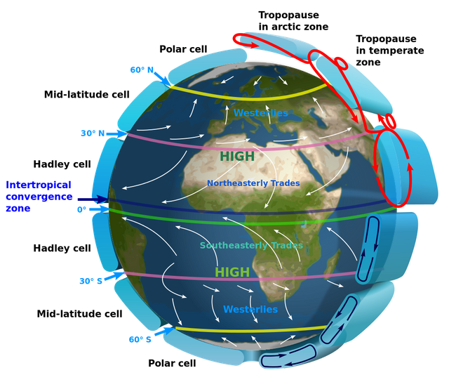
On earth, different zones can be found where atmospheric pressure is high, such as the subtropical high or zones where it is low, for example at the equator (0°). Around the equator, the so-called "Hadley-cells" are a result of rising, warm air from the equatorial regions which play an important role for the climate in the tropics as they cause massive rainfalls at the Intertropical Convergence Zone (ITCZ).
Why does a deflection occur?
It take's Earth 23 h 56 min 4,10 s to complete one rotation. Every point on earth follows this rotation, except the rotational axis. Due to gravity and friction, air particles follow this motion too. The equator is 40.075,017 km long and divides earth into a Northern and a Southern hemisphere. Thinking of earth as an ellipsoid, the distance a point on the equator passes during one rotation is bigger, than a point on a latitude below or above it. As speed is distance per time and the time for one rotation is nearly a day and therefore "fixed", a greater distance equals a higher velocity.
Throwing a ball from the equator to another latitude, for example the Northern Tropic/Tropic of Cancer, (23.43687°), it doesn’t follow a straight line as it’s trajectoy. While it heads to the Northern Hemisphere, it flies with the speed it was thrown away with. Because it was thrown from the equator, it is already 1670 km/h fast due to the angular velocity the rotation of earth causes. It has a higher velocity than the ground at the Tropic of Cancer which is about 1533 km/h fast.
Velocity at the equator:

Velocity at the Northern Tropic:

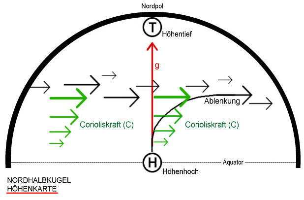
While it flies, the ground under the ball moves slower, the further it heads towards north where the latitudes are shorter -> equals less speed. It lands far right than where it would land, if the latitude would have the same length as the equator or if there would be no rotation at all. A ball thrown from the Tropic of Cancer on the other hand, is slower than the equator, resulting in a curvature of the trajectory in west-direction when it is thrown towards the equator. If the planet wouldn’t rotate, the effect wouldn’t occur too.

The green arrows show the Coriolis force, having an impact on the body that follows the red line towards the low (circle with "T" inside")
The Coriolis force and the Hadley cell
The Hadley cells were already mentioned before. They are a good example, how winds are affected by the Coriolis effect. After the hot air rises upwards at the equator, it floats towards the north and the south. A cyclone is the result of the low atmospheric-pressure in the equator region. These air masses lose height and temperature after the distance to the equator increases. They lead to a high atmospheric-pressure at the subtropical ridge (30°, but air masses can come down from between 25 to 40°) after they sink downwards and increase the atmospheric pressure at the ground. During this process, an inversion (warm air over cold), called “the trade-wind inversion” forms, preventing air from the subtropical ridge to rise. Following the pressure gradient from high to low pressure, a circle is formed as the air streams back to the equator where low pressure prevails. But because of the Coriolis effect, the winds aren’t moving from south/north to north/south. A deflection from east to west takes place and is known as the trade winds.

Northeasterly Trades and Southeasterly Trades are a result of the Coriolis effect
This happens when the winds flow back to the equator. A deflection from west to east occurs when the winds head away from the equator. While the winds at the Northern Hemisphere get deflected to the right in relation to their path, a deflection to the left happens on the Southern Hemisphere. During the year, the trade winds follow the sun peak and shift to the north or the south. Such meteorological phenomena display the Coriolis effect pretty well, but they are much complicated in the nature.
Test:
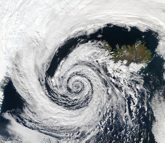
On which hemisphere is this cyclone located?

It is located on the Northern Hemisphere over Iceland and was captured by the NASA. A cyclones diameter can grow over 1000km and the picture shows, how the inward spiraling winds are rotating around the center, where the low-pressure area is located. The pressure gradient force and the Coriolis force are balanced inside of the cyclone, otherwise it would collapse. It can also collapse if the temperature difference is to low e.g. if it is above cold water. Storms like this can survive many days and can be a threat for many countries as they have a devastating power.
Have a nice day :)
Source:
Texthttps://en.wikipedia.org/wiki/Coriolis_forcehttps://en.wikipedia.org/wiki/Hadley_cellhttp://www.gerd-pfeffer.de/zirk_druckgebiete.html (translated)https://physik.wissenstexte.de/coriolis.htm (translated)https://physik.cosmos-indirekt.de/Physik-Schule/Corioliskraft (translated)https://content.meteoblue.com/de/meteoscool/grosswetterlagen/hoch-und-tiefdruckgebiete (translated)https://www.spektrum.de/lexikon/geographie/hadley-zirkulation/3299 (translated)http://wiki.bildungsserver.de/klimawandel/index.php/Passat (translated)Pictureshttps://upload.wikimedia.org/wikipedia/commons/5/5c/Coriolis-force.png Credit goes to the author: Svjohttps://upload.wikimedia.org/wikipedia/commons/thumb/9/9b/High_and_low_pressure_N_and_S.svg/557px-High_and_low_pressure_N_and_S.svg.png Credit goes to the author: BoHhttps://upload.wikimedia.org/wikipedia/commons/1/1b/Jetsteam_hoehenkarte_nordhalbkugel.png Credit goes to the author: Jimsen https://upload.wikimedia.org/wikipedia/commons/thumb/9/9c/Earth_Global_Circulation_-_en.svg/1000px-Earth_Global_Circulation_-_en.svg.png Credit goes to the author:Kaidor https://upload.wikimedia.org/wikipedia/commons/thumb/b/bc/Low_pressure_system_over_Iceland.jpg/886px-Low_pressure_system_over_Iceland.jpg Picutre Credit goes to NASAThe other pictures were made using Microsoft Word 2013 and Paint and were published on my imguraccount:https://i.imgur.com/nNAi34v.png?1https://i.imgur.com/oPqxwOs.png?2https://i.imgur.com/drZKw0t.png?2
You are always welcome to join us and get more recognition for your posts. You can find more information about geopolis here or join our Discord server.
Nice post! There are these gadgets called "Vortex Dome" And I really want one. It is also very pretty to visualize this Coriolis force and other fluid movements in general :D
Thanks :) I checked it out looks really fun to mess around with :D