20 Kickass and Amazing Landscapes on Earth
Here are 20 Kickass and Amazing Landscapes on Earth.
- Baja California riverbeds, Mexico
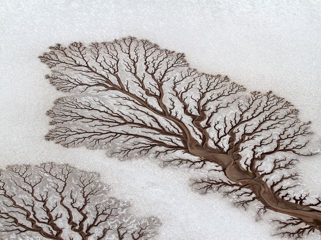
Well this certainly is a bizarre sight. In the desert of Baja California, Mexico. These are desert rivers forming treelike figures. This is no photo manipulation or a painting but a true natural phenomena you can see with your own eyes in certain periods in the year.
- Salt-Encrusted Acid Lakes of Dallol Volcano, Ethiopia
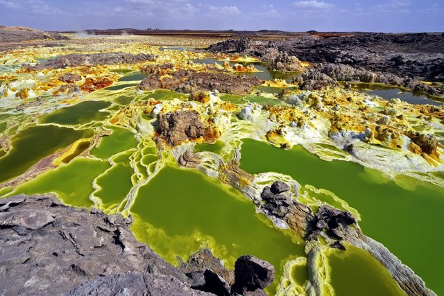
Mud, salt, iron stains, halophile algae and hot spring activity produce a colorful but dangerous landscape in the Dallol craters. The most recent was formed in 1926 by a phreatic eruption that blasted through shallow salt and sediments to produce a maar. A continuous flow of supersaline hydrothermal water feeds the colorful lakes and alters the original eruption site.
- Stone Bridges of Bulgaria
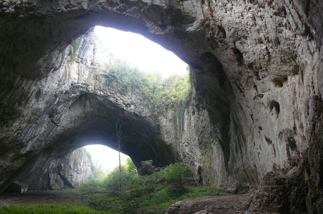
Devetashka Cave is on the way to Devetaki village. It has the biggest ‘foyer’ of all the caves in Europe – 30 metres high and 35 metres wide. According to different sources it was inhabited during 7 different epochs. It was a sanctuary in ancient times. It used to be a military base in the past. Later on in the 1950s it was used for storage of oil. According to some it was the federal reserve’s food storage and rocket base. There are 7 huge openings on the ceiling, through which natural light enters the main hall. Past the main hall the cave splits into two corridors. The left one is about 2.5 km long. It is dark with a small river running through, forming miniature lakes and waterfall, passing through the main hall and eventually flowing into Osam river. The right corridor is much smaller. It is dry and warm, ending with a round hall, known as the Altar.
- Salt marshes, Coto Doñana National Park, Spain
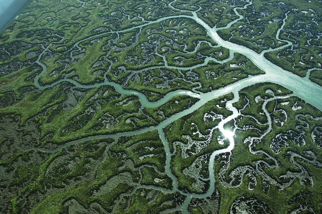
The salt marshes of southern Spain’s Coto Doñana National Park seem alive, breathing, organic, brain-like, capillary. The Doñana wetlands formed through the meanderings of the Guadalquivir River.
- White Cliffs of Dover, England
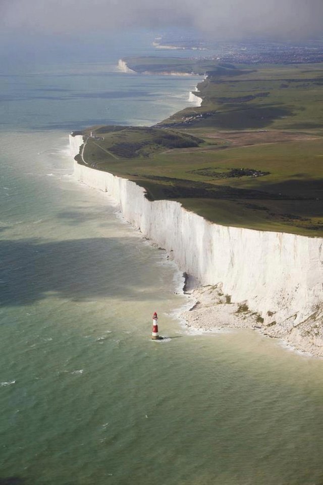
This is an iconic place is one of those natural monuments that defines what it is to be British. For almost 1,000 years, Dover Castle, perched on top of the white cliffs, has stared back at those who may have cast an envious eye at England from only 20 miles away. They are made up of billions of the crushed shells of tiny sea creatures. A hundred and fifty million years ago in the cretaceous period, these organisms gradually settled in shallow seas. The sediments built up were gradually lifted to form the chalk cliffs. These are eroded by the sea, keeping them white. But where the sea cannot reach the cliffs because of beach and sea defenses, then erosion stops and the cliffs become vegetated with trees and shrubs.
- Chartreuse Arch, French Alps
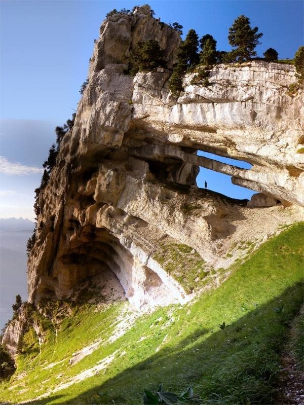
Chartreuse Mountains is a very beautiful mountain located in the Southern France. Lac du Bourget is the southernmost point of Jura Mountains in France. There is a unique double arch with the longest span of 32 meters in these mountains. The arch was only documented recently in 2005. From the arch, you can see the city in the mountains, with very picturesque scenery.
- Cappadocia’s, Turkey
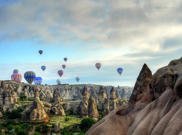
Cappadocia is an area in Central Anatolia in Turkey with the most dramatic landscape in Europe. Over thousands of years, wind and rain eroded layers of sandstone and consolidated volcanic ash to form the lunar-like landscape with fairy chimneys rock formations. During the 4th to 13th century AD, occupants of the area dug tunnels into the exposed rock face to build residences, stores, and churches which are home to irreplaceable Byzantine art. Because of the unique geological, historic, and cultural features, Cappadocia is a popular tourist destination, and hot-air ballooning is a favorite sport.
- Devils Slide, Utah
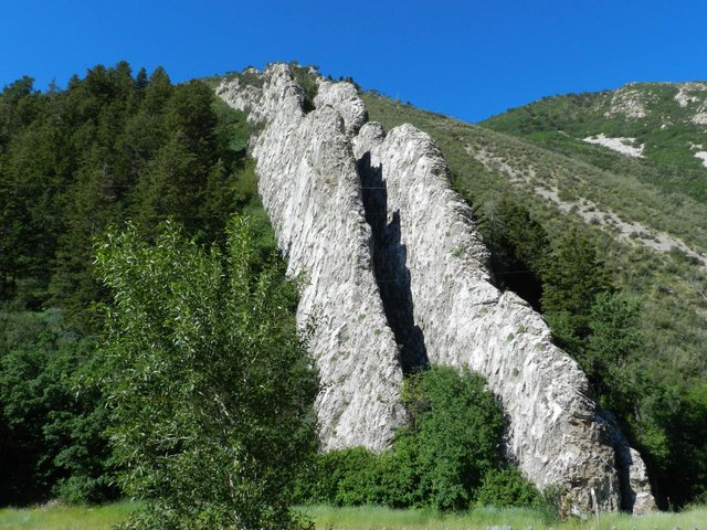
Devil’s Slide is a limestone formation alongside I-84 that looks like a giant playground slide. About 75 million years ago, shifting and folding from a mountain building episode caused the sheets to tilt vertical.
- Drake Passage, Palmer Peninsula, Antarctica
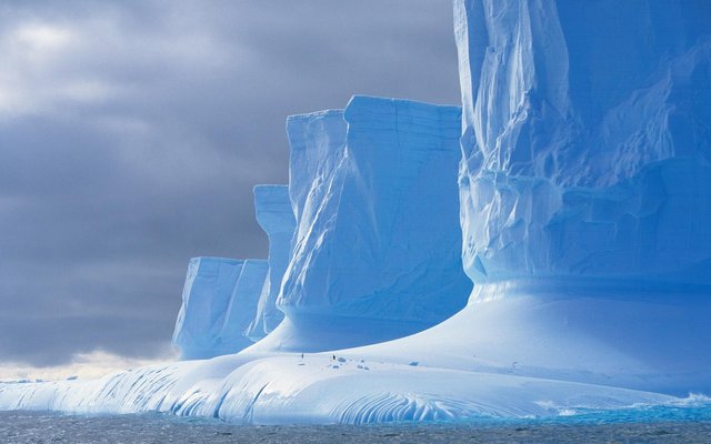
The Antarctic Peninsula is the northernmost element of mainland Antarctica, and the only part of the continent of Antarctica that extends outside the Antarctic Circle. It is approximately 1200 miles (2000 km) long, stretching from 75°S (a drawn between Cape Adams (Weddell Sea) and a point on the mainland south of Eklund Islands) to 63°S (Prime Head on the Trinity Peninsula). The southern tip of South America, Cape Horn is about 610 miles (980 km) farther north, and is separated by the Drake Passage.
- Litlanesfoss, Iceland
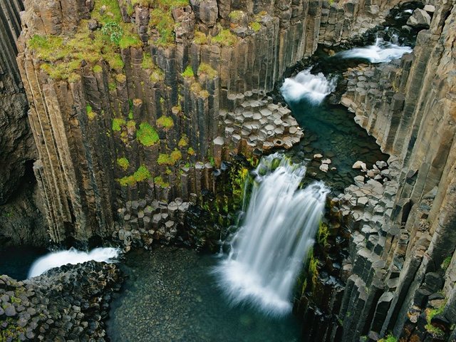
At Litlanesfoss, the waterfall cross-sections an ancient lava flow, which formed columns as it cooled.
- Waterfall Island on Iguazu Falls, Brazil
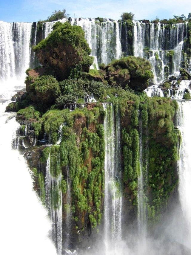
This stunning rock formation is located at Iguazu Falls. Apparently this particular view can be seen from the lookout on San Martin Island on the Argentinian side of the falls. Iguazu Falls are waterfalls of the Iguazu River located on the border of the Brazilian State of Parana and the Argentine Province of Misiones. The falls divide the river into the upper and lower Iguazu. The Iguazu River originates near the city of Curitiba. It flows through Brazil for most of its course. Below its confluence with the San Antonio River, the Iguazu River forms the boundary between Brazil and Argentina. The total height of the falls is about 60-82 meters (200-269 ft). There are approximately 275 different drops and the total width of the falls is a staggering 2.7 kilometers (1.7 miles).
- Geothermally Active Area, Northeastern Iceland
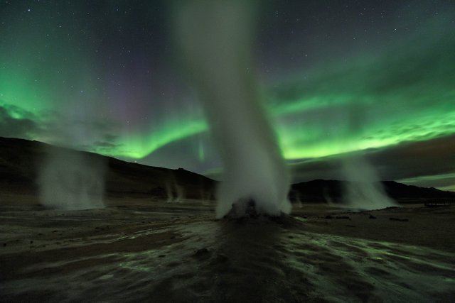
This is not a shot of an alien planet. This was shot on the dark and stormy night of September 12 at Hverir, a geothermally active area along the volcanic landscape in northeastern Iceland. Ghostly towers of steam and gas venting from fumaroles danced against the eerie greenish light of Aurora Borealis.
- Coral garden, Lizard Island, Great Barrier Reef
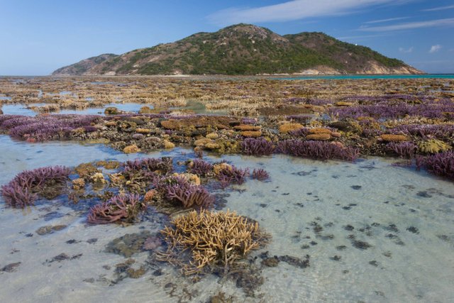
Lizard Island is Australia’s northernmost island resort. It is located 150 miles north of Cairns and 57 miles north east off the coast from Cooktown. Lizard Island is an absolute tropical paradise, a haven of isolation, gratification and relaxation. The above picture of the coral garden was shot during one of its lowest tide.
- Melissani Cave, Kefalonia Island, Greece
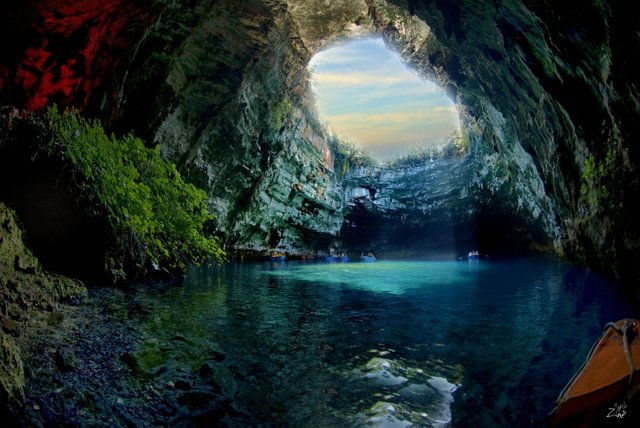
Located on the Kefalonia Island in Greece, this spectacular cave was lost for centuries until being rediscovered in 1951 by Giannis Petrocheilos. Take a look at this beautiful cave system and the island that it is part of. The famous Mytros Beach is also on this island.
- Sea cave in Algarve, Portugal
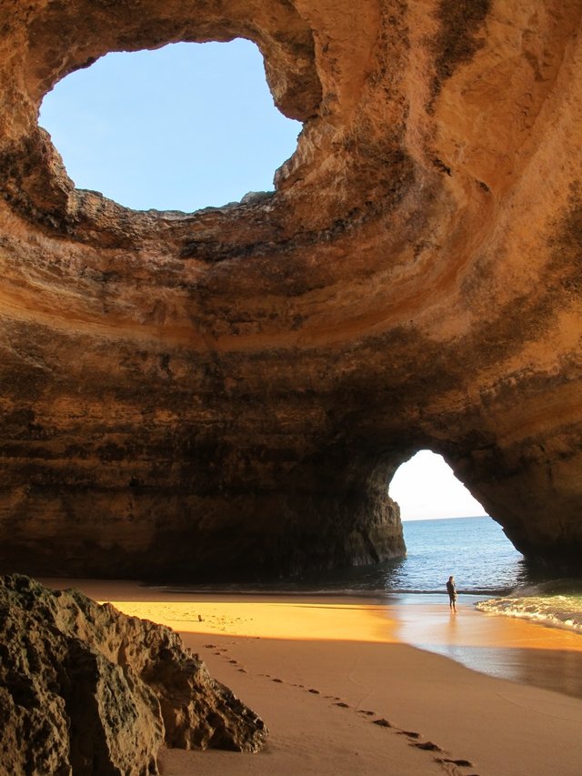
Sea caves are found throughout the world, actively forming along coastlines. A sea cave, also known as a littoral cave, is a type of cave formed primarily by the erosive wave action of the sea.
- Namib Desert
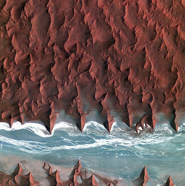
Korea’s Kompsat-2 satellite captured this image over the sand seas of the Namib Desert on 7 January 2012. The Namib is the oldest desert in the world, stretching over 2000 km along Africa’s southwestern coast from Angola, through Namibia to South Africa. Sand dunes dominate the desert – some reaching over 300 m in height. The blue and white area is the dry river bed of the Tsauchab – which only sees water following rare rainfall in the Naukluft Mountains to the east. Black dots of vegetation are concentrated close to the river’s main route, while salt deposits appear bright white. This flattened area ends about 15 km to the east at the Sossusvlei salt and clay pan (not shown).
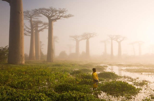
- Morondava, Madagascar

Near the city of Morondava on the west coast of Madagascar lies an ancient forest of baobab trees. Unique to Madagascar, the endemic species is sacred to the Malagasy people, and rightly so. Some of the trees here are over a thousand years old. It is a spiritual place, almost magical.
- Thousand Islands Lake, China
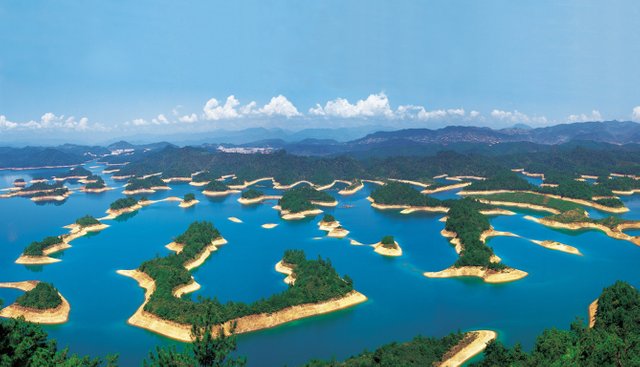
With 81% of the area covered in forests, Thousand Islets Lake (Qian Dao Lake) is a pure lake with clean, fresh air. It is a young lake formed in 1959 as a result of the construction of New Anjiang Hydroelectric Power Station. It is a beautiful lake with 1078 islets showing different views in different seasons. It is a rich lake abounding with fish and surrounded by trees, tea, mulberry (the food of the silkworm) and other fruit trees. Qian Dao Lake is also a delightful lake with many activities including enjoying the natural scenery and local culture, observing wild animals and taking part in many exciting activities.
- Turquoise Ice, Northern Lake Baikal, Russia
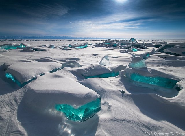
Lake Baikal, located in the southern part of eastern Siberia in Russia, is an incredible natural wonder of the world that one can only hope to visit at least once in their lifetime. It’s not just the oldest freshwater lake on Earth, at 20 to 25 million years old, it’s also one of the largest and deepest, holding an astounding one-fifth of the world’s freshwater. In the winter, for about five months or from January to May, the lake freezes over but the water is so clear that, from the surface, you can see an astounding 130 feet below you. A photographic worthy natural phenomenon occurs around a very specific time of year, March. Wind, temperature differences, frost and sun in the ice crust cause cracks and ice hummocks to form. Transparent and shining in a turquoise color, these masses of broken ice look like shards of glass rising into the sky. They are caused by the slow and unequal pressure in the main body of the packed ice as well as by the unequal structure and temperature.
- The Flatirons, Boulder, Colorado
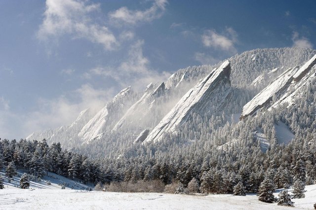
The Flatirons are remnants of the Fountain Formation, a feldspar-rich sand eroded from the ancestral Rocky Mountain uplift 300 million years ago. Sediments deposited by inland oceans compressed this layer into sandstone, thrust upward 45 million years ago by the same forces that created our modern Rocky Mountains. Water, wind, and mechanical erosion have since shaped these exposed rocks into the angular formations we see today.
@echowhale team swimming by with your upvote