Chittagong division part 1
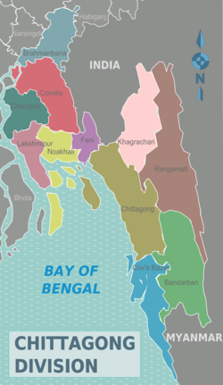
 Chittagong division is divided into 11 districts . The first six districts listed below comprise the north-western portion (37.6%) of the division, while the remaining five comprise the south-eastern portion (62.4%), the two portions being separated by the lower (or Bangladeshi) stretch of the Feni River; the upland districts of Khagrachhari, Rangamati and Bandarban together comprise that area previously known as the Chittagong Hill Tracts. Before 1995, the four districts of Sylhet Division were also a part of Chittagong Division.
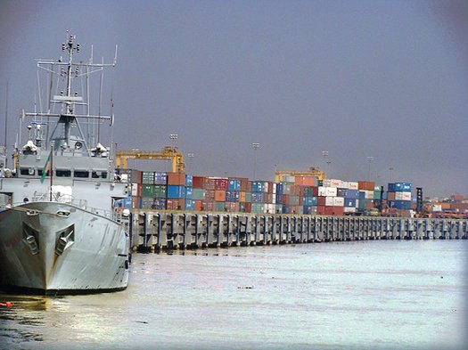
Geography and Climate: Chittagong division is locating at Bangladesh, near the Bay of Bengal. An important rail terminus and administrative center, it is the chief port of Bangladesh with modern facilities. Jute, tea, and skins and hides are the major exports; imports include cotton and other piece goods, machinery, and construction materials. Offshore oil-receiving installations were set up during the 1960s. Besides an oil refinery and oil-blending plants, the city has large cotton- and jute-processing mills, tea and match factories, chemical and engineering works, an iron and steel mill, and fruit-canning, leather-processing, and shipbuilding industries. Power for Chittagong's industry is supplied by the Karnaphuli hydroelectric project of the inland Hill Tracts District.
The port was known to the civilized world by the early centuries AD and was used by Arakanese, Arab, Persian, Portuguese , and Mughal sailors. Originally part of an ancient Hindu kingdom, Chittagong was conquered by a Buddhist king of Arakan. It passed to the Mughal empire, was retaken by the Arakanese, and again became part of the Mughal empire in the 17th cent. British control began in 1760. The city has notable Hindu temples, Buddhist ruins, several fine examples of Mughal art, a university, and many colleges.
The Chittagong Hill Tracts District, c. 5,500 sq. mi , occupies a narrow inland strip of parallel ranges along the Indian and Myanmar’s frontiers. The indigenous inhabitants are members of non-Muslim tribes who are not assimilated with the dominant Bengalis of the lowlands. Valuable timber, bamboo, and cane forests, which cover the upper reaches of the hills, support a paper industry. Cotton, rice, tea, and oilseeds are raised in the valleys between the hills, and hydroelectric stations provide power. Since 1973 tribal guerrillas have sought autonomy for the district, as well as the expulsion of of hundreds of thousands of Bangla-speaking settlers. Chittagong has been a seaport since ancient times. The region was home to the ancient Bengali Buddhist Samatata and Harikela states. It later fell under of the rule of the Gupta Empire, the Pala Empire and the Vesali kingdom of Arakan till the 7th century. Arabs traded with the port from the 9th century AD. An account by historian Lama Taranath has revealed a Buddhist king Gopichandra had his capital at Chittagong in the 10th century, and according to Tibetan tradition, Chittagong was the birthplace of 10th century Buddhist Tantric Tilayogi. In the Fourteenth Century, explorer Ibn Battuta passed through Chittagong during his travels.
Sultan Fakhruddin Mubarak Shah of Sonargaon conquered Chittagong in 1340 AD. Sultan Giasuddin Mubarak Shah constructed a highway from Chittagong to Chandpur and ordered the construction of many lavish mosques and tombs. After the defeat of Mahmud Shah in the hands of Sher Shah in 1538, the Arakanese Kingdom of Markup U regained Chittagong. From this time onward, until its conquest by the Mughals, this region was under the control of the Portuguese and the Magh pirates for 128 years. The Mughal commander Shayestha Khan and his son Buzurg Umed Khan expelled the Arakanese from the area in 1666 and established Mughal rule there. After the Arakanese expulsion, Islamabad, as the area came to be known, made great strides in economic progress. This can mainly be attributed to an efficient system of land-grants to selected diwans or faujdars to clear massive areas of hinterland and start cultivation. The Mughals, similar to the Afghans who came earlier, also built mosques having a rich contribution to the architecture in the area. What is called Chittagong today also began to have improved connections with the rest of Mughal Bengal. The city was occupied by Burmese troops shortly in First Anglo-Burmese War in 1824 and the British increasingly grew active in the region and it fell under the British Empire. The people of Chittagong made several attempts to gain independence from the British, notably on 18 November 1857 when the 2nd, 3rd, and 4th companies of the 34th Bengal Infantry Regiment stationed at Chittagong rose in rebellion and released all the prisoners from jail but were suppressed by the Kuki scouts and the Sylhet Light Infantry.
Chittagong grew at the beginning of the twentieth century after the partition of Bengal and the creation of the province of Eastern Bengal and Assam. The construction of the Assam Bengal Railway to Chittagong facilitated further development of economic growth in the city. However, revolutionaries and opposition movements grew during this time. Many people in Chittagong supported Khilafat and Non-Cooperation movements.
Congratulations @dipto! You have completed some achievement on Steemit and have been rewarded with new badge(s) :
Click on any badge to view your own Board of Honor on SteemitBoard.
For more information about SteemitBoard, click here
If you no longer want to receive notifications, reply to this comment with the word
STOP