Where Eagles Fly : Taos to Winslow ~ Part 1 ~ Preflight Planning and Beginning the Journey
This is the 1st post in a 5 post series based on an aerial exploration from Taos, New Mexico, across the desert to Winslow, Arizona across some very interesting and unusual wilderness.
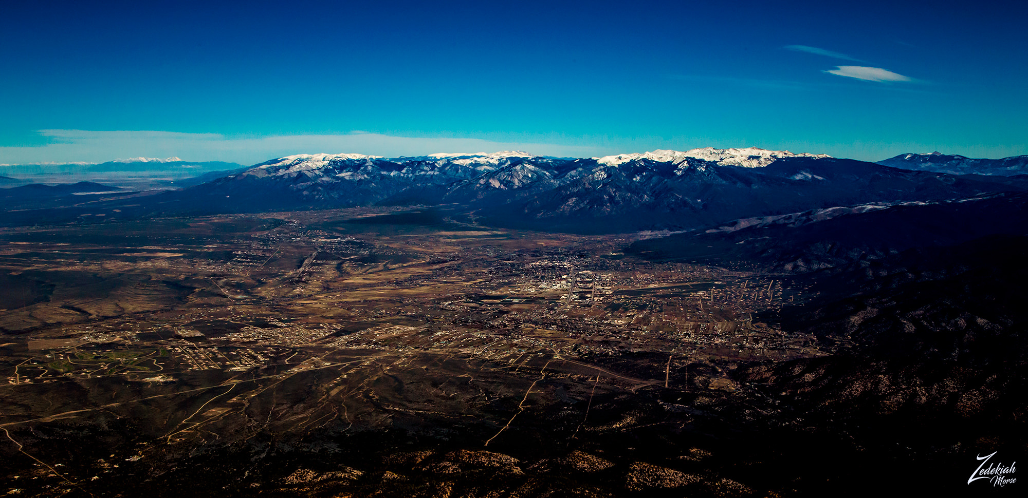 Taos, New Mexico from above ~
Click to Enlarge
Taos, New Mexico from above ~
Click to EnlargeThere are many things to consider in flying these expeditions across the remote back country wilderness. I want to show you how this is accomplished so that you can get a sense of the planning and the various factors which must be considered for a safe and successful journey.
I landed in Taos, New Mexico after flying north from Albuquerque while being chased by a storm! But I got on the ground in Taos and got the airplane secured before the rain hit hard. After getting a car into town for food and a motel room, I prepared for the next leg of my flight early the next morning. There was much to consider.
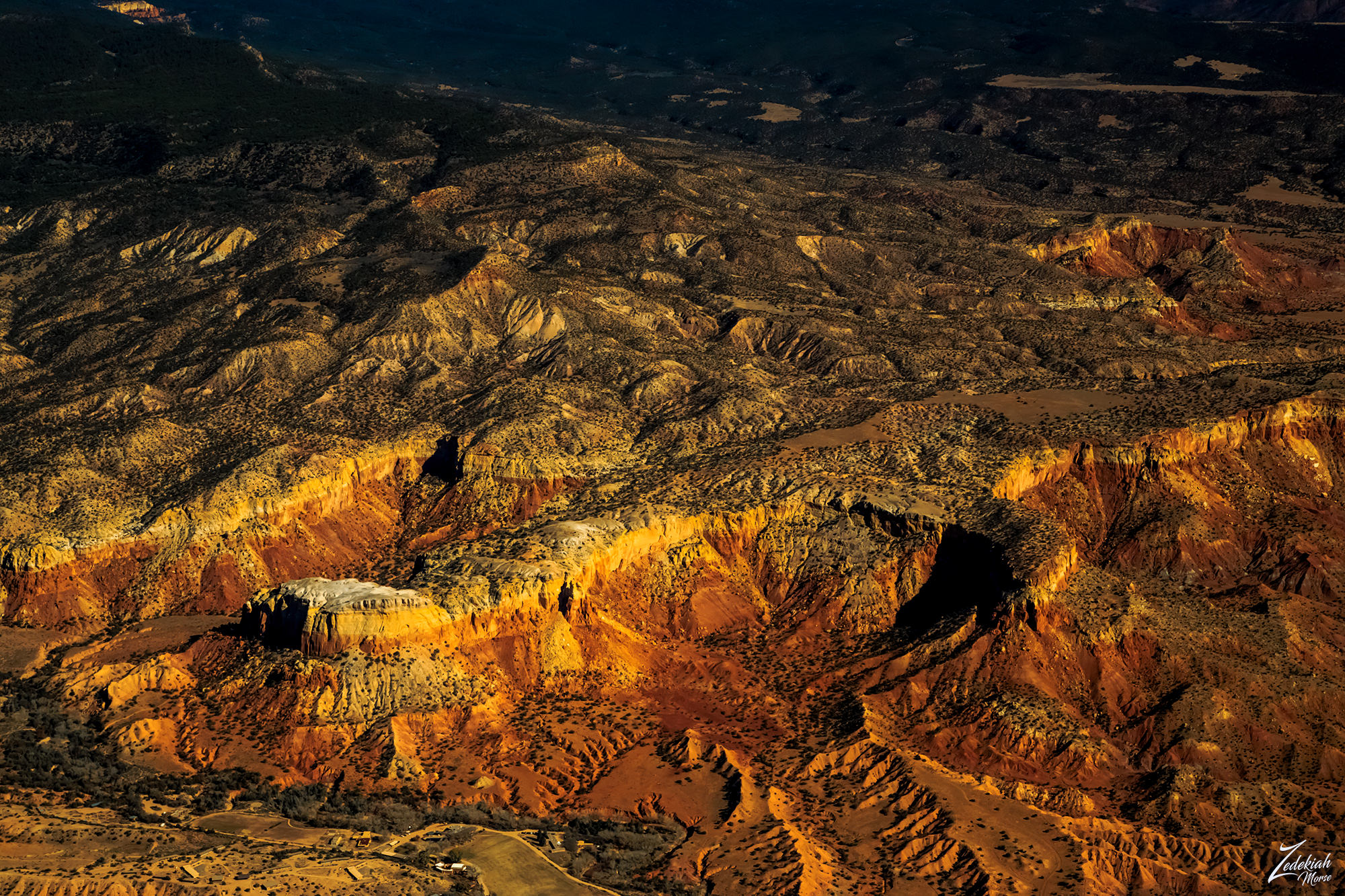
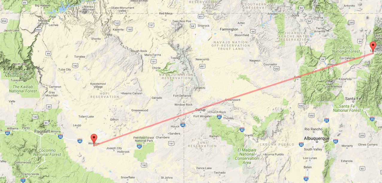 Taos to Winslow as the Crow Flies ~ Click to enlarge
Flight Planning
I consult the FAA sectional maps for the route and compare that with topographic maps to identify anything interesting I might want to shoot. Once I determine my flight route I am ready to do the flight planning.
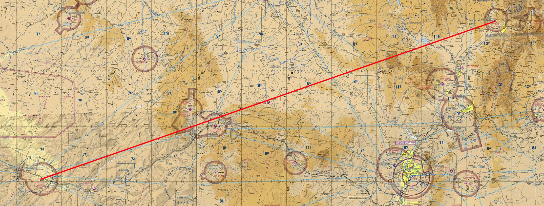 FAA Sectional Map of Flight Route
This flight is a distance of 303 miles as the crow flies. I will be climbing up and down in altitude as I cross over the different mountains and valleys on this journey so I need to figure my potential flight time to distance. Many things that must be factored in but for this post I have simplified this a great deal:
- First I check the weather forecast for conditions along the route for the time I am planning on flying. The forecast called for “severe clear” conditions with variable light to strong westerly winds along the way and at the different altitudes I was planning on flying at. This means clear visibility for miles but the wind could create issues with filming. Getting violently bounced around is always difficult when you are trying to focus for the shot and fly the airplane!
- Second I did a flight fuel/time calculation. The ground altitude in the departure location is 7,800 ft (2,377 m) and 5,000 ft (1,524 m) at my arrival location. To be able to spot interesting things below on the ground I will fly at least 2,000 ft (609 m) to 4,000 ft (1,219 m) above ground level (AGL), depending on the terrain and what I find along the way. This means I will fly between 10,000 ft (3,048 m) to 7,000 ft (2,133 m).
- Based on the known flight performance characteristics of my bush plane this means my fuel burn rate will vary with altitude from 7.1 gallons per hour at 5,000 ft (1,524 m), to 6.1 gallon per hour at 10,000 ft (3,048 m) if I maintain a prop speed of 2,500 rpm with no head or cross wind. The forecast called for variable wind along the route so the safest calculation would be a very conservative 4 hours flight time.
- This has to be factored with flight (FAR) rules that state you must land at your destination airport with at least 30 minutes of fuel on board in case the airport runway is fouled and you cannot land or fuel is unavailable and you would need to continue on to another airport. So if we take away 30 minutes that leaves us with 3.5 hours of flight time.
- The Bluebird (my bush plane) can fly an average speed of 120 miles per hour and the distance is 303 miles which translates to 2.5 hours of travel time, depending on the wind of course. This means I could possibly have about an hour of loiter time to circle locations when I find something interesting I want to photograph. Sometimes I need make a number of passes around the location at various altitudes to find the shot.
- Based on the known flight performance characteristics of my bush plane this means my fuel burn rate will vary with altitude from 7.1 gallons per hour at 5,000 ft (1,524 m), to 6.1 gallon per hour at 10,000 ft (3,048 m) if I maintain a prop speed of 2,500 rpm with no head or cross wind. The forecast called for variable wind along the route so the safest calculation would be a very conservative 4 hours flight time.
- The last thing to consider is actually really the very first pre-flight thing to do when planning these exploration flights and could be the most important. I prepare my survival gear. I carry a hefty kit which contains food, water, emergency communication and tracking equipment, camping gear, flares, weapons and first aid medical supplies. Also in my flight pants (lots of pockets) I have smaller versions of the larger kit. You never know so it is always better to be prepared.
The Journey Begins
After a good nights sleep I awoke at 4 a.m. and got to the airport at 5 and then proceeded to do my preflight inspection on the aircraft before taking off. Getting airborne at dawn I climbed to 9,500 and headed south across the Rio Grande River and headed towards the Abiquiu Reservoir and where the Rio Chama River enters the Cańon De Chama.
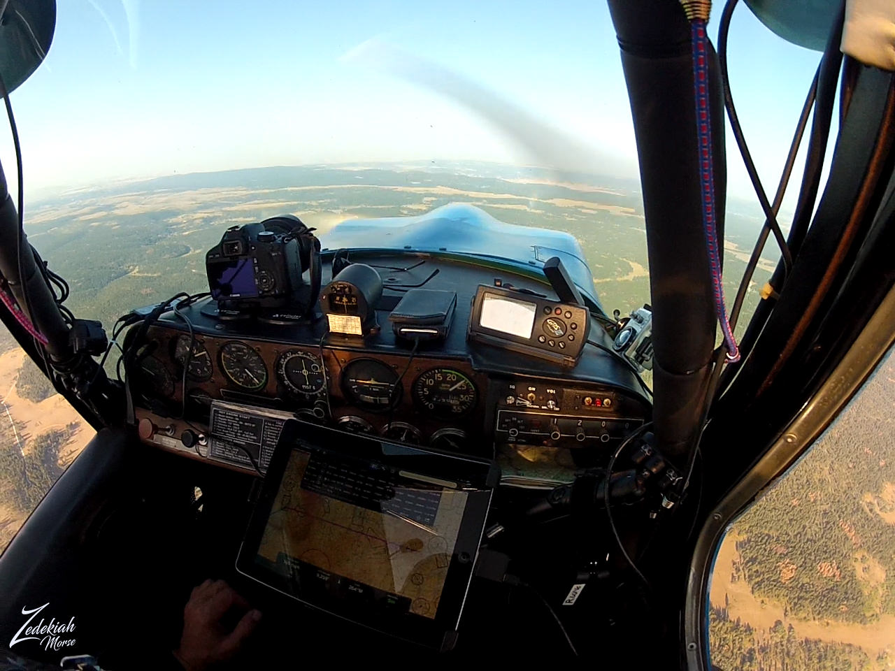 My Cockpit of the Bluebird in Flight ~ Click to Enlarge
As I reached the Abiquiu Reservoir, off to my right I noticed a very white capped protuberance on the side of the otherwise reddish and amber-brown cliffs that rimmed the lake below. This white capped mountain is known nowadays as Kitchen Mesa but the the First Nations Tewa Tribes people of San Juan Pueblo call the place "T'ibuhu'u", which is described as a low, round place they would use for their winter dances. But the Spanish settlers called the place "Piedra Lumbre" (Spanish for "Shining Rock").
 Kitchen Mesa and Ghost Ranch ~ Click to Enlarge
The Ghost Ranch
At the bottom of this white capped mountain lies a really cool historical place called the "Ghost Ranch". This is a beautiful and remote 21,000-acre (85 km2) retreat and education center which has been a source of inspiration for many artists but in particular Georgia O'Keeffe, who maintained a home and studio here, as well it was the main subject of many of her paintings.
And though this is a wonderfully peaceful place now, its origins are rather violent. The canyon was first inhabited by the Archuleta Brothers, cattle rustlers who enjoyed the coverage and invisibility that the canyon provided as well as their ability to see for miles down the valley. They created two jacal homes and would move stolen cattle throughout the night to Box Canyon. By transporting the cattle through streams, footprints would be lost and they could not be tracked. Stories of people staying with the Archuleta brothers who had gone missing (and their clothing on the men) circulated around the area.
One day one of the brothers made a transaction without the other, and claimed he had buried the gold for safety. The second brother killed him, and kept his wife and daughter hostage until they admitted to knowing where the gold was hidden. Although the mother and daughter feared the rumored spirits of the canyon, they mustered up the courage to sneak away at night through the Chama Valley. A group of local men then came to the ranch, fighting through their fear, and hung the remaining brother and his gang from a cottonwood tree that still stands next to one of the casitas on the property. Other visitors who stayed in the casita later on noted that they could hear voices of a man and a woman fighting.
(Research Source)
This is the end of Part 1 of this journey, stay tuned for Parts 2 - 5.
I lensed these images at different times while exploring this awe-inspiring wilderness area for my ongoing project, "Where Eagles Fly".
About The Project
Where Eagles Fly - The American Wilderness Expedition is my personal mission to introduce people to these amazing locations that surround us. I am piloting a bush plane while exploring and filming throughout the remote back-country areas of North America to raise awareness of the 47% of the USA and 90% of Canada that remain unpopulated wilderness.
About The Author
My name is Zedekiah Morse and I'm a Bush Pilot, Photographer, Explorer and Filmmaker. I live in the Rocky Mountains and devote my time and resources to exploring as much of the world as I can by air. If you wish to watch a short film detailing how I do my work and this project, go here.
If you like what you see here upvote and resteemit so that others may experience these wondrous places.
And if you'd like these images to be part of your feed, follow me.
Thanks for your support and Yehaw!!
Really great explanation of your whole trip. Kool robsee what goes into that.
Thanks, glad you like this format... I will post more like this since people seem to enjoy the backstory.
i like travel,thank you for article
Thanks Timor, glad you like it and thank you for your support!
thank you for information @skypilot
Awesome travel post ✌ Nice to read and see your stunning photos.
I'm looking forward to see more of it!
Thanks for taking time to read it Cowi.... I appreciate your support.
Thanks for important informations And I love journey.
Excellent! Glad you like it
Once again, awesome post! I liked that you included all of your flight planning into your writeup. I fly on P3's in the Navy (Transitioning to P8 Poseidon now). I operate, not pilot, but I am very involved in the flight planning of our missions. Flying VFR is my favorite, very scenic. It would be tough to get good shots like yours though, we are usually really high or <500 ft. but that is always over open water. Not to much sight seeing there. Thanks for another excellent post!
Hey ! very cool...I have a good friend that was an Orion pilot back a long time ago! Neat airplanes dragging that thin wire a long way out!!! Hope you are able to read the entire series. VFR is the way for me... not really anything to film inside IMC!! Glad to have you aboard my friend.... be safe.
For sure, I will take a look back through your blog to catch up. Thanks. :)
Unbelievable bird-eye views and landscapes are dizzy...i like them too much... Actually i am afraid of high or maybe it is just a fear of falling I don't know... But when I see your pictures I want to be there :)...i have talked too much... :)
Congrats and have a nice day....
LOL ! great reply!! thanks so much for your nice comment! I really appreciate it. Your reaction is what I want! I want people to be aware of these places... to want to visit them!!! So thank you so much
Incredible trip and great project @skypilot. I can not imagine if one day have the opportunity to feel this kind of adventure. Fly across different regions and enjoy the beauty of nature.
Any type of travel is good... whether you drive, take a motorcycle, bicycle or walk... any way you can see the world is awesome!
You are right @skypilot. Like me who likes touring with a motorcycle. As in 2013, I have traveled about 4000 kilometers from Aceh to Bali Island.
Welcome back my friend
Thanks my friend! good to see you again
Very interesting post)