Where Eagles Fly : Crater Butte ~ Among the Volcanic Remnants of the Snake River Plain
Black Knoll is a near perfect, classically shaped volcanic cinder pit. This ancient testament to millions of years of volcanic activity is one of a multitude of volcanic geology that dots the Snake River Plain.
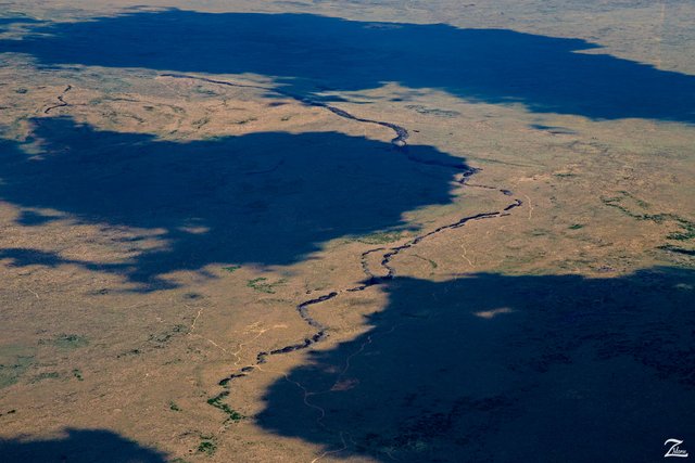 Ancient Lava Tube ~ Click to Open Full Screen
I love finding extraordinary places that are unusual an nearly impossible to see from the ground, yet from above, Where Eagles Fly... they stand out very clearly. Such was the case with these very interesting formations I found while flying and exploring the southwest edge of Yellowstone National Park.
Exposed Lava Tube ~ What an Odd Structure
As I was flying up the northeastern side of the Snake River Plain, I flew over this odd looking trench (in the 2nd image) that was basically a long ancient scar, torn across the surface of this sagebrush prairie. As you can see, initially I thought this was another river cutting across the prairie but when I got closer above it I realized that, unlike any other rivers I have seen, this has a beginning and end that were just a few miles apart. Rather strange indeed. After a great deal of research and digging around on numerous geology sites and journals I realized I had come upon a little known volcanic field located on the outskirts of Yellowstone
As I got above it I noticed that certain parts of the formation were contained, in other words, it had a "roof" or "ceiling" which created a covered surface across the formation. Then as I got above and alongside the formation I saw this tell-tale depression and realized this was obviously an ancient volcanic lava tube that was eroding and becoming exposed from above. You can see where parts of the tube still have a surface cover, (open this next picture please).
The adjacent depression was an indication of an effect of surface caving wherein the mass below this area was starting to give way to the weight of the material on the surface and was eventually going to fall into a large hole. You can see smaller holes already present next to the larger depression area.
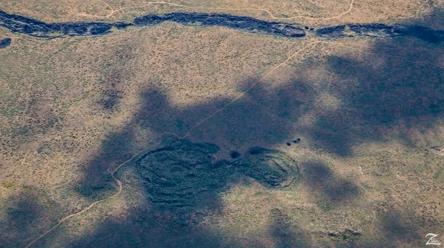 Lava Tube & Surface Depression ~ Click to Open Full Screen
Following the exposed lava tube a few more miles, I came to its beginning. (Following photo) This is a very odd formation, first of all, it is unnamed, which in and of itself is very strange. I have looked high and low on topographical maps and have read through vulcanology journals to no avail. Also what I am unclear on is whether this is a volcanic "pit" or simply a collapsed volcanic cone.
It could be either, but chances are it is the former, especially when you understand how horizontally inclined lava tubes are formed; Lava tubes are formed when molten lava flows steadily in a confined channel for many hours up to days. Over a short period of time these superheated lava-flows will develop a solid crust which then forms a roof created when bits of lava stick together and then harden.
If the molten lava stops rising from its source deep within the earth, then the lava stream that is moving inside of the now crusted-over tube, will drain away and in its place will leave an open, hollow lava tube cave that tuns the entire length of the lava flow, which can sometimes be many miles long. As in the case of this particular find.
(Research Source)
So what we are looking at here in this image is possibly the lava tube and original cinder cone that have both collapsed after the lava ran dry, leaving both the tube and this volcanic cinder pit. Whatever it is, it is very old. The last volcanic activity in this area was about 1.3 million years ago. And as you can see, even though the core of this ancient tube and pit are made of volcanic materials, there are plants growing in certain parts.
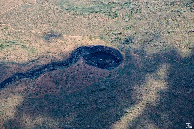 Lava Tube & Volcanic Pit ~ Click to Open Full Screen
This area this is located in is called the Snake River Plain, and it traces the path of the North American Plate over the Yellowstone hotspot, now centered in Yellowstone National Park. The eastern Snake River Plain, where this is located, is a topographic depression that cuts across Basin and Range mountain structures, more or less parallel to North American Plate motion. It is underlain almost entirely by basalt erupted from large shield volcanoes. Beneath the basalts are rhyolite lavas and ignimbrites that erupted as the lithosphere passed over the hotspot. And this is what has caused these formations to occur.
(Research Source)
The Ice Caves of Rexburg
Another interesting local phenomena are the ice caves located less than a half mile away from the cinder pit and lava tube. In the following photograph, if you look towards the top of the image you can see another exposed lava tube, similar to the one I was tracking. The exception is that this one has a large open exposed area which has, over time, become a locally well known Ice Cave you can explore. And here is a google map to its location if you want to visit yourself.
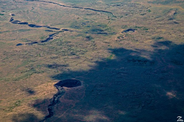 Lava Tubes ~ Volcanic Pit & Ice Caves ~ Click to Open Full Screen
Pine Butte ~ An Oasis in the Sagebrush Prairies of Idaho
To the west of the ancient volcanic lava tubes, ice caves, and cinder pit there is a double collapsed cinder pit known as Pine Butte.
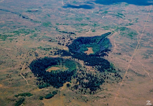 Pint Butte Double Craters ~ Click to Open Full Screen
This is about as close to a veritable oasis as you will find out here in the sagebrush prairie deserts of northeastern Idaho. Like the cinder pit above, this is an ancient volcano, albeit a double-coned volcano. But this is a very special place with its own unique forest-based micro-ecology. Looks like an interesting place to visit.
(Research Source)
I lensed these images while exploring the area from the Grand Tetons up through Yellowstone. This photo-story is from my ongoing project, "Where Eagles Fly";
About The Project
Where Eagles Fly - The American Wilderness Expedition is my personal mission to introduce people to these amazing locations that surround us. I am piloting a bush plane while exploring and filming throughout the remote back-country areas of North America to raise awareness of the 47% of the USA and 90% of Canada that remain unpopulated wilderness.
About The Author
My name is Zedekiah Morse and I'm a Bush Pilot, Photographer, Explorer and Filmmaker. I live in the Rocky Mountains and devote my time and resources to exploring as much of the world as I can by air. If you wish to watch a short film detailing how I do my work and this project, go here.
If you like what you see here upvote and resteemit so that others may experience these wondrous places.
And if you'd like these images to be part of your feed, follow me.
Thanks for your support and Yehaw!!
I love your job!! it inspires me
Thank you! I hope to keep you inspired!!
do you take these picture if yes no doubt you are a great photographer by nature
Hello, yes I take these photographs while flying my bushplane in the wilderness of North America. Thanks so much for your interest and support!
Beautiful photo
i like these kind of place ! well done skypilot keep working on and share these kind of place with us! your are mind blowing i must say i will follow you! because you are creative mind who research with us in simply way!god bless you dear
Wow, what a nice thing to say! Thank you so much for these kind comments. I appreciate you taking time to check out my work.
If you are a pilot, you cannot but be a photography blogger, and this is a great combination. There so many magnificent landscapes that can be seen only from above and you have this opportunity. Thank you for giving us this opportunity too!
Your pictures are really breathtaking and the description is very interesting and informative. I am actually afraid of flying, but I was always fascinated by the vistas down there and my dream is to have a chance to look through the cockpit window. Thanks for sharing again!
Thank you, you are spot on with your comments. There are indeed so many remarkable places I get to see from up in this special zone. I am interested in raising awareness for the protection and conservation of our wild spaces and this project is my method of choice. I am hopeful that folks will understand and appreciate my intent of these posts, and from your heartfelt comment it seems like this may well help!
You managed to deliver the message well. Hopefully your posts will make our world a little better!
Aww, you should have tagged this one geology- there's so much awesome geology in the post, after all!
Thanks so much! Actually, I choose the tags that seemingly will generate the most exposure to steemians across the platform. But yes you are correct, there is a great deal of focus pm geology in this post.
I've bee trying to grow the geology tag more- it's still pretty small, but we're making progress!
Spectacular photos of places so many have
never seen! Thank you @skypilot for all you do!!
I really like the Pint butte double craters! looks
like a mask with two eyes :-)
Thanks Shasta! I am grateful you like these photos and stories!
awesome photography Resteem
Thank you for your continued support!
Welcome i also need your support please visit to my blogs @syedwaqas
The title of your series of posts in conjunction with amazing photos make my imagination to imagine that the story is told directly from the face of the eagle, a real eagle. An indescribable feeling from reading and viewing. Thank you!
Wow! That is a very cool way of looking at this! Thanks so much for sharing that and thank you for supporting my efforts! I really appreciate it.