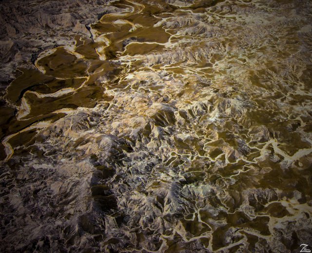
The Twisted and Tangled Landscape of South Dakota Badlands
This twisted and tangled landscape is the Badlands of South Dakota. Those white lines are thousands of rivulets, washes, creeks and streams. The larger creek on the top left of the image is called Squaw Humper Creek.
Badlands National Park (Lakota: Makȟóšiča[3]) is a national park in southwestern South Dakota that protects 242,756 acres (379.306 sq mi; 98,240 Archaeological records combined with oral traditions indicate that these people camped in secluded valleys where fresh water and game were available year round. Eroding out of the stream banks today are the rocks and charcoal of their campfires, as well as the arrowheads and tools they used to butcher bison, rabbits, and other game. ha)[1] of sharply eroded buttes, pinnacles, and spires blended with the largest undisturbed mixed grass prairie in the United States. Continue reading more here: (Research Source)
For 11,000 years, First Nations Native Americans have used this area for their hunting grounds. Long before the Lakota were the little-studied paleo-Indians, followed by the Arikara people. Their descendants live today in North Dakota as a part of the Three Affiliated Tribes.
From the top of the Badlands Wall, they could scan the area for enemies and wandering herds. If hunting was good, they might hang on into winter, before retracing their way to their villages along the Missouri River. By one hundred and fifty years ago, the Great Sioux Nation consisting of seven bands including the Oglala Lakota, had displaced the other tribes from the northern prairie. Continue reading more here: (Research Source)
I lensed this intensely abstract image while exploring the wilderness areas around western South Dakota.
This image is from my ongoing project in which I am trying to raise awareness of the 47% of the USA and 90% of Canada that remain unpopulated wilderness.
Where Eagles Fly - The American Wilderness Expedition is my personal mission to introduce people to these amazing locations that surround us.
If you like what you see here, upvote then resteemit so that others may experience these wondrous places as well. Yehaw!!

A very beautiful place, I wish to visit someday
Great job bro love the amazing landscape.... thanks for sharing this post. you have my upvote @mannyfig1956
You have the most interesting blog/progect I have found thus far on Steemit. Visuals, history, the way you get your visuals, neat facts, ect. Yehaw, sir!
Thanks so much! I do appreciate your continued support, it means so much to me, especially that you took the time to comment!
Amazing landscape! Resteemed.
Awesome! Thanks so much for helping spread the word!
Am I correct the landscape was formed when a huge glacial ice dam burst and roared to the sea?
Howdy, actually according to numerous studies it is commonly thought now that the area that makes up the Badlands National Park (in this photo) underwent a 47-million year period of deposition which spanned three major geologic periods but then were shaped as they are now largely as a result of two basic geologic processes: deposition and erosion.
Love the West. Heading to White mountains in Arizona in the spring and fall. in summer it is Cody, Wyoming and all it and the surrounding area has to offer. Thanks for your images and descriptive geography and history. Great work.
Thanks, hope your adventure is an awesome journey.