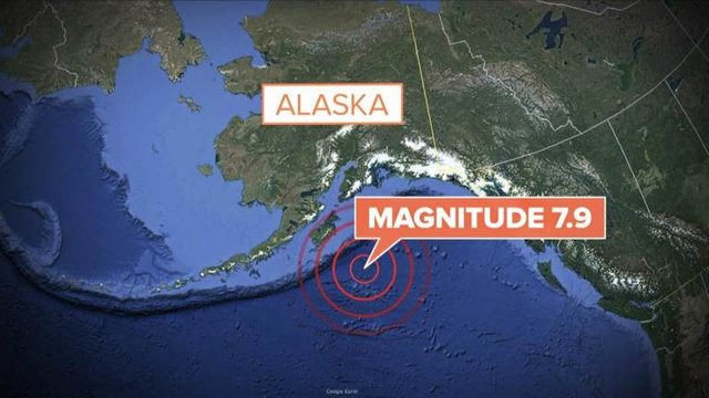
Tsunami Advisories Lifted After Alaska Earthquake

Within four hours of a major earthquake striking off the Alaskan coast early Tuesday, the authorities lifted all tsunami advisories, after initial concerns prompted guidance for coastal areas as far south as the American border with Mexico.
“A tsunami was generated by this event, but no longer poses a threat,” a message from the United States National Tsunami Warning Center said just after 4 a.m. in Alaska.
The magnitude 7.9 quake was reported at 12:31 a.m. local time in the Gulf of Alaska, about 170 miles off Alaska, according to the United States Geological Survey. There were no immediate reports of damage.
The center reported that a small tsunami with a wave height of less than eight inches was observed in the Alaska towns of Old Harbor, Seward and Kodiak.
Tsunami sirens went off in Kodiak after the earthquake. “Evacuate inland or to higher ground above and beyond designated tsunami hazard zones or move to an upper floor of a multistory building depending on your situation,” the authorities warned on Tsunami.gov. “Move out of the water, off the beach, and away from harbors, marinas, breakwaters, bays and inlets.”
Stephanie Wyzkoski, 42, who co-owns the Cranky Crow Bed and Breakfast in Kodiak with her husband, John, said emergency workers “told everyone to evacuate in the lower areas of town.”
“People are going to the high school and the town pool to evacuate,” she said.
“We are quite high up,” she added. “We are close to the hospital, so we have opened up our house to friends.”
After urging residents to seek higher ground, the police in Kodiak said that one popular area — Pillar Mountain — was at capacity. The police urged people to go instead to the local high school or to the Safeway or Walmart parking lots.
The warnings included San Francisco, where the authorities told people living within five blocks of the bay that they might need to evacuate.
The region of the Gulf of Alaska where the quake hit is part of a large subduction zone, where one large piece of the earth’s surface, or plate — in this case the floor of the Pacific Ocean — is slowly sliding under another — the North American continent. The Alaska subduction zone is the source of many earthquakes, including one in 1964 that at magnitude 9.2 was the second largest ever recorded.
But in a brief analysis of Tuesday’s quake released several hours afterward, the United States Geological Survey said it occurred not on a sloping thrust fault like the one that moved in 1964, but rather on a near-vertical strike-slip fault. That, the geological survey said, was “consistent with it occurring on a fault system within the Pacific plate before it subducts, rather than on the plate boundary between the Pacific and North America plates further to the northwest.”
Peter J. Haeussler, a research geologist with the survey in Anchorage, said that it appeared likely that the slip occurred at a bulge in the Pacific plate where it bends as it starts to slide under the continent. Such a bulge is referred to as an “outer rise,” he said.
The direction of the fault movement in this case would be horizontal — more like the San Andreas fault in California — and would be less likely to generate large tsunamis, Dr. Haeussler said.
He said that tide gauges on Kodiak Island showed a small tsunami, of less than a foot, but the high water arrived more than an hour after it had been expected. It was possible that the wave was created by underwater slumping of sediments during the quake somewhere in the Gulf of Alaska, he said.
Dr. Haeussler said he had been awakened by the quake at his home north of Anchorage, more than 350 miles from the epicenter, and that the shaking had lasted about a minute. By comparison, ground-shaking lasted about four and a half minutes during the 1964 quake.
He said he had spoken to a colleague on Kodiak Island, closer to the epicenter, who had felt a long, gentle rolling from the quake.

Geologists and residents of the West Coast have long been aware of the threat of “the big one.” A 2015 article in The New Yorker described, in occasionally terrifying detail, an expected megaquake in the Cascadia subduction zone, off the coast of the Pacific Northwest.
After the quake on Tuesday, Gov. Bill Walker of Alaska urged residents to “heed local warnings to move inland or to higher ground.”
The Alaska Earthquake Center, which is affiliated with the University of Alaska Fairbanks, reported a series of aftershocks, the largest of which registered preliminarily as a 5.3.
“Given the location and type of mainshock, we anticipate vigorous aftershocks in the magnitude 4-5 range and can expect aftershocks of magnitude 6 or larger,” the center said in a post on Twitter. “We have no reason to suspect a follow-on earthquake of comparable, or larger, size than the M7.9 mainshock.”
Tuesday’s quake came nearly seven years after Japan was rattled by a 9.0-magnitude earthquake, the strongest ever recorded there. The earthquake set off a powerful tsunami that breached the sea walls of coastal towns, killing at least 15,000 people and sparking a major crisis at the Fukushima Daiichi Nuclear Power Station.
A 9.1-magnitude earthquake, one of the most powerful ever recorded, struck off the Indonesian island of Sumatra in December 2004, generating enormous waves that killed more than 230,000 people, mostly in Indonesia but also in India, Sri Lanka, Thailand and as far away as Somalia.
condolence to the people affected.
Congratulations @littlesweety! You received a personal award!
Click here to view your Board
Congratulations @littlesweety! You received a personal award!
You can view your badges on your Steem Board and compare to others on the Steem Ranking
Vote for @Steemitboard as a witness to get one more award and increased upvotes!