Creeping earth could hold secret to deadly landslides
Scientists investigate why mountain slopes can slip slowly for years and then suddenly speed up, with potentially fatal effects.
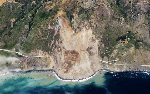
After inching along for two years, the Mud Creek landslide quickly obliterated a section of California's Highway 1 in May.
The explosive volcano Sabancaya looms large over the hamlet of Maca in southern Peru. Smoky plumes frequently spew from the mountain and sometimes rain ash down on the town. But the geological threat that keeps Maca's residents up at night is not 15 kilometres away at Sabancaya, but right underfoot.
For about 30 years, the very ground around Maca has been in retreat. Some 60 million cubic metres of earth — the equivalent of more than 20,000 Olympic swimming pools — are slinking their way to the valley floor and taking part of the town with them.
The impact of this slow-moving landslide is clearly visible: in recent years, it has destroyed a section of the region's main road and torn apart farmland, threatening the community's key source of income. What is not clear is the landslide's future: whether it will continue to lurch along as it always has or speed up dramatically, potentially endangering lives. “It's like a sword of Damocles hanging over the town,” says Pascal Lacroix, a geoscientist at the Institute for Earth Science in Grenoble, France.
In some ways, Maca is not unique. Landslides are a major threat in all the mountainous regions of the world, killing thousands of people each year. Many, such as the devastating Regent slide in Sierra Leone last week, are fast and furious. Others, like the one threatening Maca, play out slowly, with hillsides slipping a few centimetres to a few metres each year.
Those slow-moving landslides rarely claim lives, but can inflict serious damage on houses and infrastructure. And although they may amble along for months or years, they can also speed up unexpectedly, with sometimes fatal consequences.
The Vajont landslide in the Italian Alps, for example, moved slowly for at least 3 years before accelerating and killing as many as 2,500 people in 1963. More recently, the 2014 Oso slide in Washington state killed 43 people. In the weeks before, some residents reportedly saw the slow creep of the land above. And after two years of slow movement, the Mud Creek landslide in Big Sur, California, rapidly wiped out half a kilometre of the state's popular Highway 1 in May this year.
Such speed-ups may be common. It's almost certain that every fast landslide started as a slow one, says William Schulz of the Landslides Hazards Program at the United States Geological Survey (USGS) in Golden, Colorado. “Just no one noticed.”
Now, geologists are noticing. They have, in recent years, begun to take advantage of improved sensor technology — as well as advances in radar imaging and laser ranging — to study these slow-motion natural disasters. And they are poised to identify more slow landslides with the help of the European Space Agency's two Sentinel-2 satellites, the second of which launched in March. These eyes in the sky can between them snap a picture of the same portion of the Earth every five days, allowing scientists to spot new areas of movement and monitor them for changes that could herald a dangerous slide.
Ultimately, scientists hope to develop enough of an understanding of these lethargic landslides to be able to predict when they might pick up speed. “One of the great questions really, for us as geologists, is under what circumstances does a slow-moving landslide become a catastrophic landslide,” says natural-hazards specialist Dave Petley of the University of Sheffield, UK. “I think technology is giving us insights that we've struggled to gain for a long time.”
Science in slow motion
The world's most well-studied slow landslide is hard to miss amid the San Juan mountains of southwestern Colorado. A congealed mass of yellow soil and boulders topped by tilted trees sticks out amid the forest-covered slopes. Called the Slumgullion slide, it has an active zone that snakes its way nearly 4 kilometres down a hillside. Scientists have spent more than a century studying this 20-million-cubic-metre mess, named by settlers to the region after an everything-but-the-kitchen-sink-style stew. In places, it is hard to walk more than a few metres without tripping over a field computer, a sensor or one of the many other instruments that dot its surface.
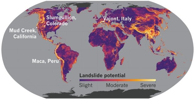
Topography, vegetation loss and other factors leave many areas of the globe susceptible to landslides, which can be triggered by rainfall and earthquakes.
Expand
Slumgullion is a sensitive beast. Although it has trundled along fairly steadily for the past 300 years, its pace changes dramatically on a daily basis in response to snowmelt, rainfall and even the ebb and flow of air pressure.
The main mover of earth — here and elsewhere — is water. Researchers can see that clearly in data they collected from ground overlooking Slumgullion using Interferometric synthetic aperture radar (InSAR). InSAR compares radar images of the land taken at different times to determine how its surface has deformed. When scientists used it to track the slide's movement, they found1 that a mere quarter of a millimetre of rain can cause the ground to speed up by a factor of five within just a few hours. Minor changes in groundwater pressure are enough to trigger the change.
The fact that a large, complex landslide such as Slumgullion reacts to the slightest amount of rain helps to explain why the more common, smaller slides can be even more sensitive, says Schulz. A two-metre-deep slide — less than one-fifth the depth of Slumgullion — can start swiftly because rainfall can destabilize its full volume rapidly. And because it is shallow, it is likely to have few geometric and geological irregularities that can hinder motion.
Geologists are learning that many factors determine whether a landslide moves quickly when it rains. Important influences include the shape, roughness and composition of a slide's underside, or base; the proportions of the base to the sides; and the slide's depth, especially in relation to the water table.
One site that has proved particularly helpful in teasing apart the impact of geometry and other factors is northern California's Eel River basin. There, researchers have mapped approximately 200 slow-moving landslides and are currently monitoring 10 or so using InSAR. These slides all reside in almost identical geological settings and climates; only their sizes and shapes differ.
At Eel River, scientists have learnt that not every landslide has a hair-trigger response to rainfall: it can rain for weeks or months before there is movement. The team has found2 that the fine-grained composition of these landslides, rather than geometry or climate, has the largest role in determining their behaviour. “In general, fine-grained soils with clay-rich material have a slower response, and course-grained soils or rocks with large cracks or fissures have a faster response,” says Alexander Handwerger, a geoscientist at NASA's Jet Propulsion Laboratory in Pasadena, California.
But pulling all this information together to make predictions will be a challenge. For decades, geologists have been gathering data to better quantify the correlations between landslide motion and the duration and intensity of rainfall. But geological materials and hydrologic conditions are infinitely variable, Schulz says, and the level of accuracy needed to forecast slides is still beyond scientists' reach. What's more, in many countries, landslide motion is also heavily affected by another phenomenon whose influence hasn't been so thoroughly studied: earthquakes.
Earthquakes in the equation
Seismic shaking is a fact of life in the Colca Valley, where Maca sits. Quakes come several times a year, and the hills around the town are streaked with tan-coloured scarps — the telltale sign of fallen earth — that stand out against the green backdrop of painstakingly carved farming terraces. More than a dozen major earthquakes have hit the town since 1990. One of the most devastating in recent memory occurred in 1991, when a shallow, magnitude-5.4 earthquake destroyed the western part of the village. It killed 14 people and knocked down half of the town's centrepiece, a small white church called Santa Ana.
By then, the villagers had noticed that land on the outskirts of town was on the move. As concerns grew, the Geophysical Institute of Peru in Lima installed three temporary Global Positioning System (GPS) units between 2001 and 2004 to monitor the motion. In the years since, the land has continued its march, creating fissures in farmland that widen each year and draw away water meant for crops. Unable to keep the land productive, nearly one-third of the town's population has left in the past decade.
In 2011, scientists from Peru's Mining and Metallurgical Geological Institute (INGEMMET) in Arequipa, along with Lacroix and colleagues based in France, began to step up the monitoring with the installation of permanent GPS instruments. The sensors were in place in time to catch the effects of a magnitude-6 earthquake that struck during the dry season of 2013, its epicentre less than 20 kilometres from Maca. The Maca landslide is usually stationary during that part of the year, but sensors showed3 that it moved 2 centimetres during the quake, followed by a further 6 centimetres over the next 5 weeks — a small amount for the wet season but anomalous for a time with no rainfall.
Researchers observed even more curious behaviour in August 2016, when a magnitude-5.4 earthquake hit the region. Inspecting the data, Lacroix found that they mirrored the findings from three years earlier: seismic shocks sped up the Maca landslide during the quake and over the following weeks. This time, however, he observed that when the rainy season came and triggered further motion, the earth and debris moved much faster than normal for that time of year.
Lacroix put together a rough model of what had happened. As seismic waves hit a slope, they can trigger movement that continues well after the original shock. In the case of Maca's landslide, he says, that movement slows down eventually, owing to an increase in friction during sliding — a behaviour that has also been proposed to describe creep along geological faults. For other slides, however, the initial motion can reduce friction, and so help the slide to speed up. The difference comes down to both internal factors, such as the material properties of the earth, and external ones, including temperature, pressure and gravity.
Landslides without sufficient braking can speed up catastrophically after an earthquake or rainfall triggers their motion. With Maca, however, the friction becomes stronger once the earth starts to slide, and works to slow it down.
But this braking activity can be undermined by earthquakes. The ground-shaking can loosen the material of the landslide and weaken it. The seismic shocks can also open holes and cracks in its body, providing more pathways for water to infiltrate the soil. Lacroix thinks that earthquake damage in 2016 left the Maca landslide prone to faster movement when the next rainfall came. Further damage could potentially lead to more catastrophic speed-ups. “Even a small earthquake can create large effects,” he says.
The whole picture
By fitting various pieces — rainfall, geometry, earthquakes and more — into the puzzle, scientists are starting to understand what causes landslides to start, speed up or stop. But how far can observations be translated to different sites?
“Each case is, to some degree, unique,” says Richard Iverson, a hydrologist at the USGS's Cascades Volcano Observatory in Vancouver, Washington. “The materials are so variable from place to place, and some of those nuanced differences can really make a difference in the behaviour.” Schulz concurs, but he stresses that even landslides separated by great distances can share properties and behaviours. By studying a wide range of them, scientists can find the underlying rules that link environmental triggers to movement.
Hundreds of residents of La Conchita, California, could attest to that point. The hillside behind their community had been moving for several months before it finally accelerated in 1995, following heavy rains. County officials and consultants, however, had been able to use data from standard surveying instruments to detect the slope's imminent failure and warn residents to evacuate.
Now, remote sensors, such as the Sentinel-2 satellites, could help to extend the study and monitoring of landslides to areas that are too difficult or expensive to study on the ground. “Instrumenting all slow landslides is not possible, so remote-sensing data really is the future for monitoring a whole territory,” says Lacroix.
Already, using such data, Lacroix and his colleagues have found4 that there is a landslide near the village of Madrigal, 6 kilometres from Maca, that behaves much like the Maca slide during the rainy season. As in Maca, the movement is affecting the locals' ability to farm the land. But should the slide speed up, it could block the river running through the valley, forming a dammed lake. “If the dam then breached, it could create floods,” Lacroix says.
Aware of this possibility, the international team installed the first instrument on the Madrigal landslide in May, to monitor its behaviour. It took nearly a week to build the red-brick housing — a metre or so high — used to protect the GPS instrument from theft and weather damage. The sensor sits on farmland that has supported crops for nearly 2,000 years, the very picture of permanence and stability. But beneath it, the ground slowly creeps.
@cyberwatch666
Resteem. Upvote. Follow.