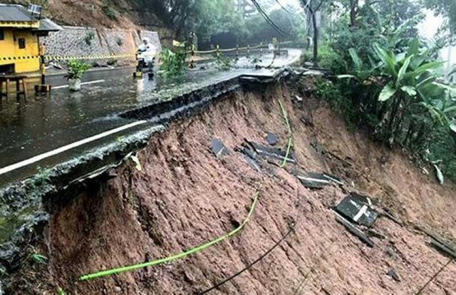
alert for landslides of natural disasters caused by high rainfall

High rainfall in recent days, triggered a landslide in the form of landslides in Bogor District, Cianjur, and Underpass Perimeter Road Soekarno Hatta Airport.
Center for Volcanology and Geological Hazard Mitigation (PVMBG), Geological Agency, Ministry of Energy and Mineral Resources (ESDM) asks the public to always be aware of the movement of pitch causing landslides, of course this can happen at any time, especially to those who live in areas of disaster prone areas.
Head of Ground Movement Mitigation Division of PVMBG, Geological Agency, Ministry of ESDM, Agus Budianto said, landslide movement is the movement of slope-forming materials, in the form of rocks, piles of soil or mixture material that moves down and out of the slopes.
He continued, several factors that control the occurrence of soil movement include slopes and morphology, geological conditions, water conditions / hydrological slopes, changes in land use and construction failures.
"The trigger of landslide movement is generally from high rainfall, earthquake and human activities (slope cutting, blasting on the mining area)," said Agus some time ago, as written, (08/02).
Agus explained, Indonesia is a tropical climate so that weathering will run very effectively. In addition, morphology in Bogor Regency is generally in the form of hills and mountains with steep slopes that are built by sediment and soil weathering volcanoes.
"Uncontrolled activity also causes avalanche potential or movement of soil will increase if rainfall is high.In addition, due to the earthquake also causes the slope to be reduced in strength so that if the rainy season landslide-prone areas become more and more," explained Agus, quoted by the official site esdm .go.id.
Furthermore, Agus said, to mitigate the disaster landslide movement, Geological Agency routinely at the beginning of the month to create a Book forecasting Potential Territory of Land Movement in Indonesia that contains maps and general information of potential areas of land and banjir bandang movement in Indonesia.
The estimates are based on the results of overlapping between maps of vulnerable zones of land movements issued by the Geological Agency with Rainfall Forecast Map published by the Meteorology Climatology and Geophysics Agency (BMKG), so that the potential map of the soil movement will change depending on the rainfall forecast map monthly.
"The Forecast Map The occurrence of Soil Movement can be used as a reference for early warning of ground movement during above normal rainfall, in districts / municipalities prone to landslides / landslides," he said
Thanks @goodkarma