Concurso de la comunidad #Steem-BRU | ¿A qué distancia vive de donde nació? | Venezolano-English | Escrito original de @theatrorve | Viernes 10 09 2021 | #Steem-BRU

Emoji creado en Bitmoji. Diagramación de mi autoría
Concurso de la comunidad #Steem-BRU
¿A qué distancia vive de donde nació?
Escrito original de @theatrorve
Viernes 10 09 2021
#Steem-BRU
Venezolano


¡Saludos!... Un cordial saludo a los miembros de la comunidad #steem-bru y al resto de la gran familia #steemit.
La presente publicación es para participar en el concurso ¿A QUÉ DISTANCIA VIVE DE DONDE NACIÓ? Organizado por @slon21veka en esta comunidad.

Me parece muy interesante la temática del concurso y me agrada mucho poder compartir parte de mi historia escribiendo sobre el lugar de mi nacimiento y el lugar donde hago vida actualmente.
Comenzare escribiéndoles un poco sobre la ciudad donde nací. Caracas, es la capital de la República Bolivariana de Venezuela. Ubicada en la zona centro-norte costero del país.
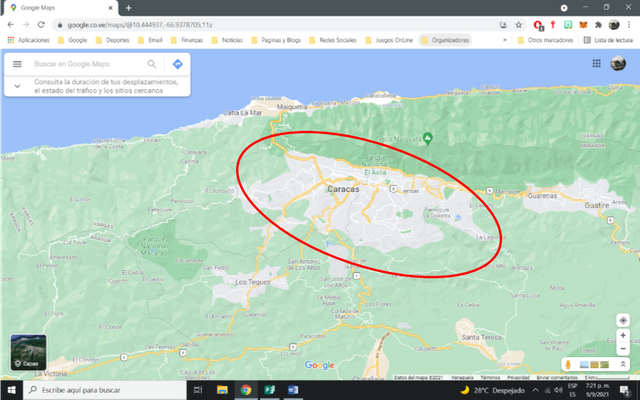
Ubicación de la ciudad de Caracas, según mapa googleFuente
Fue fundada en el año de 1567 bajo el nombre de Santiago de León de Caracas por el conquistador español Diego de Losada. Se extiende en un valle a 900 metros sobre el nivel del mar y está separada de las costas venezolana por una imponente montaña llamada Waraira Repano que proviene del dialecto indígena de la etnia Caribe y que significa, según algunos lingüistas, ”Sierra Grande”
Viví en la capital de la republica desde mi nacimiento hasta el año 1984 donde por el cambio de la situación socio-económica-política del país, mi familia se vio obligada a emigrar hacia el interior del país y es allí donde llego a San Juan de Los morros, capital del estado central llanero Guárico.
Para llegar desde la ciudad de Caracas a la pequeña ciudad de San Juan de Los Morros el viajero debe tomar la autopista regional del centro, vía que es la más importante para lograr la comunicación entre la capital de la republica hacia el centro, sur y occidente del país.
Dicha arteria vial cruza tres de los estados más importante del país, el estado Miranda, el estado Aragua y el estado Carabobo en donde dicha vía culmina en la entrada de la ciudad de Valencia, capital del estado Carabobo.
Ubicación de la Encrucijada de Aragua, según mapa googleFuente
Sin embargo, para llegar a la capital del estado Guárico no es necesario recorrer toda esta autopista. Se podría decir que a mitad del recorrido de la misma no encontramos con un sector denominado La Encrucijada de Aragua lugar ubicado en el estado Aragua y que sirve como importante bifurcación vial en el centro del país
Este es quizás un paso obligatorio de los viajes que se dirigen desde el occidente, centro y el sur de Venezuela y en caso inverso. Es un lugar que se podría catalogar como emblemático y que está cerca de la ciudad de Maracay, capital del Estado Aragua.
Esta aproximadamente a 71 km de distancia en línea recta desde Caracas y a 91 km en distancia en ruta desde el mimo punto de origen. A una velocidad de 80 kilómetros por hora se estima un tiempo de viaje de 1 h 17 min.
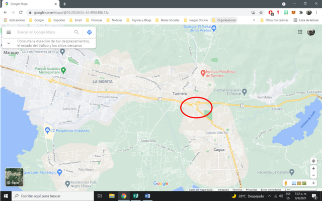
Ubicación de la pequeña ciudad industrial de Cagua, según mapa googleFuente
Se toma la vía Los Llanos al salir de la encrucijada para dirigirnos a nuestro destino. Esta vía es llamada perimetral. Está en el escalafón entre carretera y autopista. Una vía de dos canales por sentido de circulación y con gran afluencia vehicular tanto de vehículos livianos como vehículos de varga pesada.
El primer poblado por donde pasa en viajero es la pequeña ciudad industrial de Cagua ubicada en el estado Aragua y en donde hace vida productiva importantes empresas nacionales y transnacionales.
Esta pequeña ciudad industrial tiene una importancia productiva de gran calibre en el centro del país. La perimetral atraviesa este poblado de lado a lado. Se ubica a una distancia aproximada de distancia de 71.78 km de la capital de la república, en línea recta y a unos 110 km en distancia de ruta. 1 hora 19 min es el tiempo estimado de viaje a una velocidad de 80 kilometros por hora.
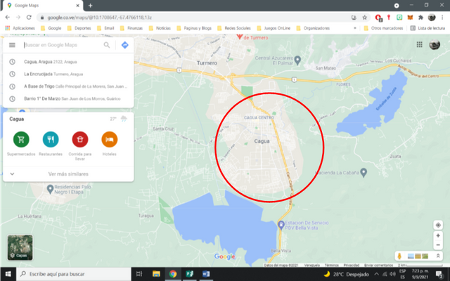
Ubicación de la Villa de Cura, según mapa googleFuente
Salimos de Cagua y recorremos la vía de los Llanos hasta llegar al poblado de Villa de Cura. Este poblado es el último existente del estado Aragua. Digamos que es el límite del sur del estado.
Este poblado tuvo a finales del siglo 17 una importancia my grande dentro del esquema nacional de Venezuela. En la actualidad este poblado muestras muchas características coloniales que han sido resguardada con mucho recelo por los oriundos de este pueblo.
Está a unos 83.12 km de distancia, en línea recta, de la capital de la república y a unos 131 km de distancia, en tuta. De la misma. El tiempo de viaje desde la ciudad de Caracas es de 1 hora 37 min a una velocidad promedio de 80 kilómetros por hora.
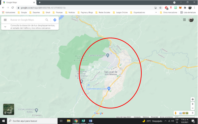
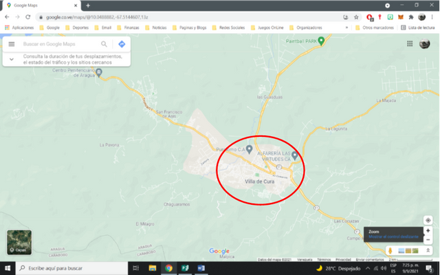
Ubicación de la San Juan de Los Morros, según mapa googleFuente
Siguiendo con el camino salimos de Villa de Cura para cruzar el limite estatal que divide los estados Aragua y Guárico, para inmediatamente llegar a San Juan de los Morros, Capital del estado Guárico. Ciudad donde vivo desde 1984.
Cuando llegue a esta ciudad, fue para mí, un cambio muy radical en mi estilo de vida. Venia de vivir en una metrópolis de gran escala como lo era Caracas en aquellos años y San Juan de Los Morros no se le acercaba en nada en este aspecto.
Esta ciudad está ubicada a unos 82.50 km de distancia, en línea recta, de la ciudad de Caracas. El recorrido vial es de unos 140 km de distancia de la capital de la republica con un tiempo aproximado de viaje de 1 hora 52 min con una velocidad promedio de 80 kilómetros por hora.
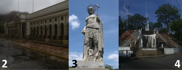
Posee un atractivo turístico natural denominado Los Morros de San Juan(1), o monumento Arístides Rojas nombre oficial, el cual da el apellido a la ciudad. Una formación de rocas calizas arrecifal.
Otra atracción que posee la ciudad es la estatua de Sanjuanote(3) o San Juan Bautista construida en el periodo de la dictadura del General Juan Vicente Gomes a principio del siglo 20.
Los Baños termales son una de las principales atracciones visitadas en la ciudad. Construida en la época del Generalísimo Juan Vicente Gómez y muy frecuentada por esta a raíz de las aguas témales sulfurosas que se encuentran en dicho lugar
Por ser capital del estado en esta ciudad se concentran los poderes políticos del estado teniendo en ella las sedes principales de la Gobernación del Estado Guárico(2), Consejo legislativo y sede estatales de los principales ministerios nacionales.
La ciudad es sede de una de las universidades más importante del país. La Universidad Rómulo Gallegos ostenta un buen nivel entre las universidades del país a pesar de ser una de las más jóvenes existente en el sistema universitario nacional.
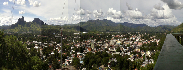
A la ciudad se le apoda con el nombre de La puesta de los Llanos venezolanos al encontrase, geográficamente hablando, al comienzo de los llanos venezolano. Esto se pude comprobar a medida que se avanza hacia dicho territorio a través de las vías de comunicación terrestre. El cambio de la geografía a nivel visual lo demuestra.
El monumento a la Bandera(4), La villa Olímpica, La Plaza Bolívar, El Cero Platillon, El Balneario el Castrero, entre otros sitios son de visita casi obligada por el turista que visita esta ciudad.
En la actualidad la ciudad ha crecido en cantidad de habitante y en extensión de zonas de viviendas. La vida nocturna se mantiene a niveles bajos ya que todavía es factible las reuniones en las diferentes calles entre amigos para compartir alguna bebida o alguna reunión social.
Esta es la ciudad donde hago vida diaria en la actualidad y Caracas la ciudad donde nací hace algunas vueltas atrás al almanaque. Espero que esta publicación sea del agrado de quienes la lean.

Hasta la próxima…
Invito a @josevas217, @jacorv, @bunker.universe, @fuentesjo3006, @emy.pets05, a que se unan a este concurso
Si quieres conocerme un poco más visita mi publicación de presentación en Steem atreves de este enlace
Gracias a @slon21veka y @Steem-BRU por dejarme participar en este concurso.

Emoji created in Bitmoji. Diagramming of my authorship.
Steem-BRU-community contest
How far do you live from where you were born
Original writing by @theatrorve
Friday 10 09 2021
#Steem-BRU
English


Greetings!... A cordial greeting to the members of the #steem-bru community and the rest of the great #steemit family.
This post is to participate in the contest HOW FAR DO YOU LIVE FROM WHERE YOU WERE BORN? Organized by @slon21veka in this community.
I find the theme of the contest very interesting and I am very pleased to be able to share part of my story by writing about the place of my birth and the place where I currently live.
I will begin by writing a little about the city where I was born. Caracas, is the capital of the Bolivarian Republic of Venezuela***. It is located in the central-north coastal area of the country.
Location of the city of Caracas, according to google mapSource
It was founded in 1567 under the name of Santiago de León de Caracas by the Spanish conquistador Diego de Losada. It extends in a valley 900 meters above sea level and is separated from the Venezuelan coast by an imposing mountain called Waraira Repano which comes from the indigenous dialect of the Caribbean ethnic group and means, according to some linguists, " Garnde saw".
I lived in the capital of the republic since my birth until 1984, when due to the change of the socio-economic-political situation of the country, my family was forced to emigrate to the interior of the country and it is there where I arrived to San Juan de Los Morros, capital of the central plains state Guárico.
To get from the city of Caracas to the small town of San Juan de Los Morros the traveler must take the regional highway of the center, the most important way to achieve communication between the capital of the republic to the center, south and west of the country.
This highway crosses three of the most important states of the country, Miranda state, Aragua state and Carabobo state, where it ends at the entrance to the city of Valencia, capital of Carabobo state.
Location of the Encrucijada de Aragua, according to google mapSource
However, to reach the capital of the state of Guárico it is not necessary to travel the entire length of this highway. It could be said that in the middle of the route we find a sector called La Encrucijada de Aragua, located in the state of Aragua and which serves as an important road fork in the center of the country.
This is perhaps an obligatory stop for those traveling from the west, center and south of Venezuela and vice versa. It is a place that could be catalogued as emblematic and is close to the city of Maracay, capital of Aragua State.
It is approximately 71 km away in a straight line from Caracas and 91 km en route from the same point of origin. At a speed of 80 kilometers per hour, the estimated travel time is 1 h 17 min.
Location of the small industrial town of Cagua, according to google mapSource
We take the Los Llanos road when leaving the crossroads to go to our destination. This road is called perimetral. It is located between the highway and the freeway. It is a two-way road with a large number of vehicles, both light and heavy vehicles.
The first town through which the traveler passes is the small industrial city of Cagua, located in the state of Aragua, where important national and transnational companies are productive.
This small industrial city is of great productive importance in the center of the country. The perimeter road crosses this town from side to side. It is located at an approximate distance of 71.78 km from the capital of the republic, in a straight line and about 110 km in route distance. 1 hour 19 minutes is the estimated travel time at a speed of 80 kilometers per hour.
We take Los Llanos road when leaving the crossroads to go to our destination. This road is called perimetral. It is located between the highway and the freeway. It is a two-way road with a large number of vehicles, both light and heavy vehicles.
The first town through which the traveler passes is the small industrial city of Cagua, located in the state of Aragua, where important national and transnational companies are productive.
This small industrial city is of great productive importance in the center of the country. The perimeter road crosses this town from side to side. It is located at an approximate distance of 71.78 km from the capital of the republic, in a straight line and about 110 km in route distance. 1 hour 19 min is the estimated travel time at a speed of 80 kilometers per hour.
Location of Villa de Cura, according to google mapSource
We leave Cagua and drive along the Llanos road until we reach the village of Villa de Cura. This town is the last existing town in the state of Aragua. Let's say that it is the limit of the south of the state.
This town had at the end of the 17th century a very great importance within the national scheme of Venezuela. At the present time this town shows many colonial characteristics that have been guarded with much suspicion by the natives of this town.
It is about 83.12 km away, in a straight line, from the capital of the republic and about 131 km away, in tuta. From the same. The travel time from the city of Caracas is 1 hour 37 min at an average speed of 80 kilometers per hour.
Location of San Juan de Los Morros, as per google mapSource
Following the road we left Villa de Cura to cross the state border that divides the states of Aragua and Guárico, to immediately reach San Juan de los Morros, capital of the state of Guárico. City where I live since 1984.
When I arrived in this city, it was for me, a very radical change in my lifestyle. I came from living in a large-scale metropolis like Caracas in those years and San Juan de los Morros was nowhere near it in this aspect.
This city is located about 82.50 km away, as the crow flies, from the city of Caracas. The road distance is about 140 km from the capital of the republic with an approximate travel time of 1 hour 52 min with an average speed of 80 kilometers per hour.
It has a natural tourist attraction called Los Morros de San Juan(1), or monument Aristides Rojas official name, which gives the surname to the city. It is a reef formation of limestone rocks.
Another attraction of the city is the statue of Sanjuanote(3) or San Juan Bautista built during the dictatorship of General Juan Vicente Gomes at the beginning of the 20th century.
The thermal baths are one of the main attractions visited in the city. Built in the time of Generalissimo Juan Vicente Gómez and very frequented by this one as a result of the sulfurous thermal waters that are in this place.
For being the capital of the state in this city are concentrated the political powers of the state having in it the main headquarters of the Governorate of Guárico State(2), Legislative Council and state headquarters of the main national ministries.
The city is home to one of the most important universities in the country. The Rómulo Gallegos University boasts a good level among the country's universities despite being one of the youngest existing in the national university system.
The city is nicknamed La puesta de los Llanos venezolanos (the put of the Venezuelan plains***) because it is located, geographically speaking, at the beginning of the Venezuelan plains. This can be verified as one advances towards this territory through the terrestrial communication routes. The change of the geography at visual level demonstrates it.
The monument to the Flag(4), the Olympic Village, Bolivar Square, El Cero Platillon, El Castrero Spa, among other sites are almost obligatory for the tourist who visits this city.
At present the city has grown in number of inhabitants and in extension of housing areas. The night life remains at low levels since it is still feasible to meet in the different streets among friends to share a drink or a social gathering.
This is the city where I live nowadays and Caracas is the city where I was born a few turns ago. I hope this publication is to the liking of those who read it.

See you next time...
I invite @josevas217, @jacorv, @bunker.universe, @fuentesjo3006, @emy.pets05, to join this contest.
If you want to get to know me a bit more visit my Steem presentation post through this link
Thanks to @slon21veka and @Steem-BRU for letting me participate in this contest
Twitter
Прекрасный пост! Спасибо за участие!
Mucha suerte Bro! Mi participación será apoyandote, si participo en el concurso te ganaría (ah carajo, creando el problema ahhaha)
Jajajajaja bueno @jacorv... Te reto a que lo intentes.... Suerte con ello.
Hasta la próxima...