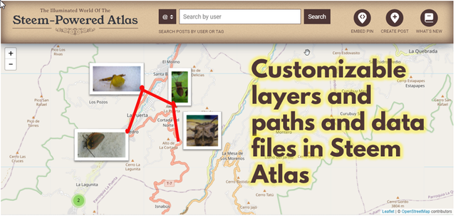
Customizable layers and paths and data files in Steem Atlas.
 |
|---|

A proposal towards integration
Greetings, Steemians.
The Steem Atlas Project is proposed as a dapp within Steemit, with a lot of potential for the creation of content that involves location and geolocation on virtual maps. Although I do not consider myself a technology "Nerd", for years I have enjoyed the use of maps for some activities. Especially for one of my hobbies: macrophotography in general and insect photography in particular.

More than a hobby, it is already an art for me, as I seek to give that special touch to the photographs that raises them to an artistic level, rather than a scientific one. Although I know that I am still a novice. But, returning to the subject of maps, I have taken advantage of this type of outdoor activity to create a compilation of insect and plant species in the town where I live: La Puerta, Trujillo. Venezuela.
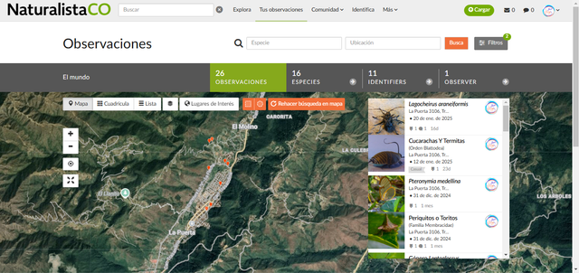 Capture o my dashboard: @joslud I'm doing this compilation on the Inaturalist.org platform, where I've already reported more than 26 observations. |
|---|
When I saw the reactivation of the Steem Atlas project, the first thing I thought of was using it for this purpose, that is, making publications of insects with their photographs, adding the place and the conditions in which I photographed them.

The problem I see.
However, I notice that I still don't know how to do it in Steem Atlas, since it only allows uploading geographic markers (called pins) or a publication that includes a single place. But, if I want to, for example, mark a route, or include observations from different dates, the only option is to reflect it in the text of the publication, without being able to view it in the Steem Atlas interface, either as an individual layer or as a route that includes several pins at the same time.
In that order of ideas, in addition to simple markers, custom markers with different icons could be included to represent different types of data
I recognize that I may be seeing the glass half empty and I don't know if that can be achieved at present or if they will be improvements that will be incorporated over time in Steem Atlas.
Benefits that I see from incorporating individual layers and routes.
✅ I could, using an KML or CSV file, transfer a map from Google, or from some application with geolocation, directly to a Steem Atlas layer, and the system would locate the marked points according to the coordinates.
✅ Think of all the possible contests that could be created: fitness by places or kilometers traveled, evidence of treasure hunts, the “Ten Pic of my city” and so on.
✅ It would enhance the interaction of more users directly with the Steem Atlas interface. Making it more attractive, just by entering to upload a post.
Insects, Insect, Bird, Birds, Nature
When searching for the tag: insects, insect, nature, the results were discouraging for me.
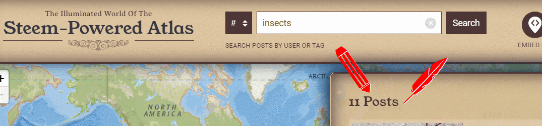 Captures on Steem Atlas Insects: 11 posts; Insect: 4 posts; Bird: 30 posts; Birds: 66 Post; Nature: 0 post. |
|---|
Being a topic with extensive SEO searches, I believe that incorporating the study of nature within Steem Atlas would benefit the positioning of Steemit and attract content creators within these topics, and even form active communities in Steemit.
Conclusions
Since I learned about its reactivation, I see that Steem Atlas has great potential to become a platform within Steemit, very versatile for the creation of geographic content and collaboration between Steemians and communities.
I believe that incorporating layers, personalized tours and other functionalities could significantly expand its reach, attractiveness and usefulness.
For the target of nature observers, Steem Atlas represents a tool that can facilitate the recording and sharing of observations on biodiversity, other related topics.
Opening up the ability to incorporate data via KML or CSV files into Steem Atlas opens up possibilities for integration with citizen science platforms such as iNaturalist or eBird.
More Proyecto Steem Atlas
| Solicitud de curador comunitario de Steem Atlas | ACTUALIZACIÓN DE STEEM ATLAS AL 27 DE ENERO DE 2025 | Pautas de curación para febrero de 2025 |
|---|
Imágenes
Las imágenes son de mi propiedad.
 Original production by @joslud -- #wox-joslud |
Hola parcero personalmente creo que ese tipo de actividades deben impulsarlas mas y hacerles mas publicidad para que sea conocida y las personas puedan hacer publicaciones sin ningún contratiempo, espero traiga mejoras y un impulso a la plataforma.
Saludos