Skies Clear Tonight Sunshine Through Wednesday Showers Thursday
DOWNLOAD MY NEW FREE JOESTRADAMUS WEATHER APP FOR ALL DEVICES
(Unsupported https://www.facebook.com/plugins/post.php?href=https%3A%2F%2Fwww.facebook.com%2Fmeteorologistjoecioffi%2Fposts%2F10161417866420387&width=500)


Tuesday we should see lots of sunshine and a bit of temperature recovery with highs reaching the mid to upper 40s. Wednesday should be the nicest day of the work week with lots of sunshine with highs in the 50s. There could be local sea breezes developing Wednesday afternoon over the South Shore and the East End of the island and that will knock temperatures back down into the 40s.

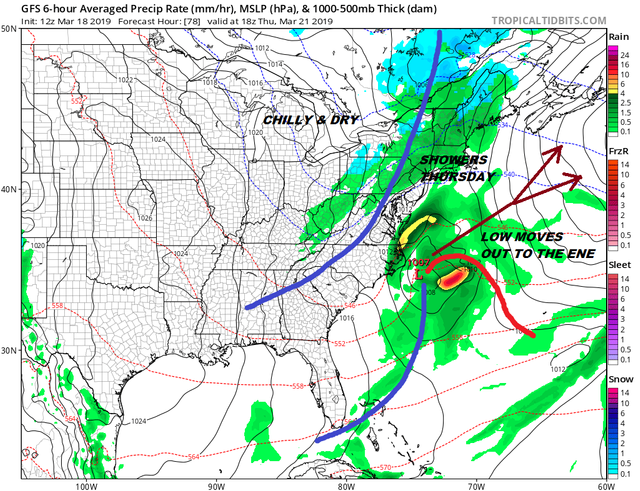
Thursday brings a cold front from the northwest. There will be a low that will cross Florida and head off the Southeast Coast as well. Weather models all winter along have tried to bring these storms northward only to see them get kicked away to the east and offshore. Even though some models show otherwise we think that that northern stream feature that supports the cold front will suppress this system out to the east and kick it away. Even if it were to move northward the atmosphere would not be supportive for snow here, just an enhanced period of rain. Temperatures on Thursday will reach into the 50s. Friday look for clouds and some sun with highs in the 40s with the risk of a few passing showers. Saturday and Sunday look good. 50s seem likely on Saturday and 60s are possible inland Sunday depending on the wind direction.
Please note that with regards to any tropical storms or hurricanes, should a storm be threatening, please consult your local National Weather Service office or your local government officials about what action you should be taking to protect life and property.
Posted from my blog with SteemPress : https://www.weatherlongisland.com/skies-clear-tonight-sunshine-through-wednesday-showers-thursday/