Barry Stops One NYC Heatwave But May Cause Another
Barry Stops One NYC Heatwave But May Cause Another
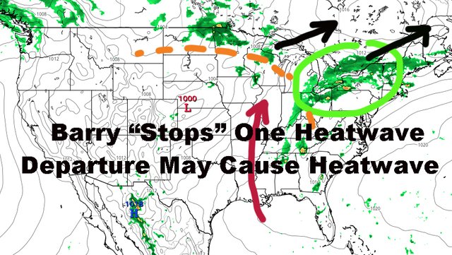
Good morning everyone. We've been talking about this hot weather possible for over 2 weeks now and throwing the word "heatwave" around. Had it not been for Barry (which couldn't been seen that far out), we would've certainly got one on paper. Now that he may do just enough to ruin one by a few degrees on Thursday, his departure may cause the heat to explode like letting the kink in hose go.
SATELLITE

Tomorrow we turn up the juice a bit until things get somewhat oppressive on Wednesday; increasing humidity and highs in the upper 80's to low 90's tomorrow.

On Wednesday, whatever is left of Barry will begin to influence the area. It's biggest contributor will be the humidity that dying tropical systems bring, not the rain. Expect sun and clouds, muggy, and the slight chance of a few tropical showers and storms in the afternoon; highs in the 90-95 realm.
Thursday will be the kink in the hose (heatwave-wise) as Barry's remnants look to enhance a front before pulling NE. We'll have a better chance of tropical showers and storms, still scattered in nature, but maybe enough clouds to keep us in the muggy upper 80 to near 90 range.

With Barry departing and leaving a void of air behind it, could be just enough to really heat things up for Friday onward. Originally, we had an inclination that Saturday could be very hot, with a bonus day possible Sunday if the front held back.
Right now, Friday could be a sneaky one depending on how Barry and his front depart, possibly sending us into the 95-100 realm. Also, if a front doesn't sag down from our north, we could be looking at that bonus day on Sunday; so as of now and until I see otherwise, look for 95-100 Saturday and Sunday, with our bonus day now being Monday as the main part of a much bigger system pushing through.

We'll call it "Heatwave: Delayed", as Barry marginalizes one by just a few degrees, then allows the floodgates to open on the heat afterwards. Remember, it's still hot regardless, so take proper precautions when venturing out this entire week aside from today.
Please note that with regards to any tropical storms or hurricanes, should a storm be threatening, please consult your local National Weather Service office or your local government officials about what action you should be taking to protect life and property.
Posted from my blog with SteemPress : https://www.nycweathernow.com/barry-stops-one-nyc-heatwave-but-may-cause-another/