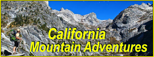
My California - Crafts Peak

For this weeks Show Us Your California contest by @socalsteemit I headed up into the San Bernardino mountains for a fun overnight backpacking trip to...
Crafts Peak!!

So I met up with my buddy Ryan and after a few quick stops for food/drinks we headed up Highway 330 into the San Bernardino mountains. At some point years ago I had seen some pictures of Crafts peak and had thought to myself "that would be a great spot to hammock camp". And 4 years ago I attempted to do just that. On that trip I had started at Green Valley Lake, but unfortunately a late start and a locked gate that added miles to the hike ended with me running out of time and camping about a half mile below the peak. It was still a fun trip and the next morning I still made it up to the peak. And if you're interested you can read about it in this post. But I still felt like I had failed and so ever since then I've wanted to go back and achieve my goal... and that time had finally come. This time we took a different route. We started at Lakeview point on highway 18 just above Snow Valley resort. From there we hiked straight up the ridge line that rises up above the section of the highway known as the Artic Circle, which I've been calling Lakeview Ridge although that is an unofficial name. It starts by following a steep fire break up to some type of radio tower. Beyond the tower there was a less steep section, but it didn't last long and soon enough we were once again going straight up the steep fire break. And not only was it steep, but our packs were heavy due to having to carry all our water for the night. Increasing the difficulty. At some point the fire break disappeared and we just had to find our own route. As we were getting to the top of a point along the ridge we ended up getting a little off track. We decided to try going around the point instead of going straight over the top which ended up being a mistake and we ended up having to cross a bunch more snow than we would have otherwise had to deal with. Before crossing the snow we stopped for a quick water/snack break and then headed down through a saddle and started climbing once again. After this climb we got up to the plateau where I had ended up camping on my previous trip and we once again stopped for a quick break on a log there to enjoy the views. We were hitting quite a bit of snow now and beyond the plateau we had one more drop in the ridge before starting the final climb to the peak. The last few hundred feet there was a lot of snow, and it was a bit slippery, but besides one big post hole where I sunk down hip deep, we made it fine and were stoked to be on the summit!

Getting ready at the trailhead

Looking up the start of the fire break

The radio tower

Our first view of Crafts Peak

Climbing up the steep firebreak
In the background you can see the San Gorgonio range as well as some smoke from a controlled burn near Angeles Oaks

Crossing the snow

Dropping down through the saddle

Views from the ridge

Views from the plateau

The final climb to the summit

Approaching the summit

The summit

Views from the summit looking down at Lakeview Ridge and Snow Valley resort behind it

Views from the peak looking towards Big Bear lake
Up on the summit we rested for a bit just enjoying the amazing 360 degree views. Then we got out our daypacks and threw in some snacks and water. We hung the rest of our food up a tree just in case a hungry animal came by. And then we headed east along the ridge towards Butler peak which we were hoping to climb as well. But unfortunately lots of thick buckthorn to push through and much more snow than we were expecting made for slow travel and about halfway across the ridge we came to the realization that we were not going to have enough time to make it there and back before dark and so Butler peak would have to be an adventure for another day. So we found a rock outcrop along the ridge to sit on for a short break and then retreated back to Crafts peak to get our camp setup. We got our hammocks hung up and got on some warmer clothes and then had some dinner while watching the sunset and the city lights below us come on. It started getting a little breezy, but all in all it was a lovely evening. Once we were tucked away in our hammocks for the night the wind picked up more and it got quite cold. Ryan had a new under quilt and wind tarp for his hammock so he was able to stay warm. Me, well... I survived. lol.

Starting our attempt to Butler peak

Crossing the patches of snow and buckthorn

Navigating through buckthorn

Views of San Gorgonio from within the buckthorn

Butler Peak (on the left) still looking very far away

Views NW from the ridge

More views toward San Gorgonio

Ryan at our turnaround point, Butler Peak still looking pretty far

Back at Crafts peak, with our food still hanging in the tree

Ryan in his hammock

Sunset
In the morning I woke up to a beautiful sunrise, but unfortunately it was still to cold for me to get up and get good pictures. But eventually the wind died down and the sun started warming things up and we got up and had some breakfast and signed the summit register. After that we got our stuff all packed up and started making our way back down. It was another beautiful day. The valley below was all socked in with clouds, but up on the mountains it was a clear bluebird day. Going down was a lot easier than going up, but there was still a couple steep climbs and a few technical snow crossings. And on the way down we found the better route from the saddle up and over the point in the ridge instead of going around. And from there it was just down, down, down. Down passed the radio tower and back to the trailhead. It was another really great trip. Ryan is an excellent hiking partner and I'm stoked he was able to come with me to finally achieve my 4+ years old goal of hammock camping on Crafts peak!!

In my hammock at sunrise

Summit sign in the morning

My hammock(front) and Ryan's hammock(back)

Morning views looking west

Morning views looking North


Selfie before starting down the mountain

The first of the two climbs on the way down

The second climb over the point in the ridge

Hiking down

Going back passed the radio tower

Getting back down to the trailhead on highway 18
Besides being an excellent hiker Ryan is also a great videographer and you should totally check out this awesome video he made of our trip!
And so until next time...
I hope you have enjoyed this glimpse into
My California!!


#SoCalSteemit is building and supporting the Steemit community of Southern California. If you are from SoCal and are into creating quality content here on Steemit, we'd love for you to follow us @SoCalSteemit and join our group on Discord
Awesome hike! Sounds like a chilly night at the peak but glad you made it through… thanks for sharing!!